Houston British Columbia Map
Customize this Houston British Columbia Map around the area of your interest such as a business location, sales territory or anything you like. You can zoom the map in or out, center on your location through search or move it around. You can preview the map again after the adjustments before ordering. We will ship a high quality print of your selection in the orientation, size & paper finish of your choice.
We also offer a premium version of this Houston British Columbia Map using TomTom's map data starting at $39.99. If you have any questions, we will be happy to answer over the phone (866) 525-2298 or write to us
We also offer a premium version of this Houston British Columbia Map using TomTom's map data starting at $39.99. If you have any questions, we will be happy to answer over the phone (866) 525-2298 or write to us
Houston BC Map
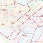
Houston BC map is ideal for the business owner who needs local or regional road network information about the city. The map highlights Houston Municipal, Town, and Zip Code boundaries. You can also locate the major road, highway infrastructures with detailed street labeling.
Use this map for planning deliveries, catchment area or sales territory. To customize the map around your preferred location click on 'Close Preview' button on the map. Before placing an order, select a size, orientation, and finishing material of your choice.
About Houston BC
The town of Houston in the Bulkley Valley of the Northern Interior of British Columbia is known as the town of forestry, mining, and tourism. It is also known as the "steelhead capital" and it has the world's largest fly fishing rod. Their tourism industry is based on ecotourism and Steelhead Park. The town has a total land area of 72.94 km2 (28.16 sq mi) and a population density of 41.0/km2 (106/sq mi).
Houston has rich wildlife and it is not uncommon to spot moose, deer, black bear, grizzly bear, cougars and so on. The famous Nanika River feeds the Morice Lake in the region and produces sockeye salmon.
History
This area was first charted by amateur historian, cartographer, and geologist, Reverend Adrien-Gabriel Morice (1859-1938). He came to BC as a Catholic missionary to the native people and was one of the first 'white men' to see most of the area. He wrote about the area in "The History of the Northern Interior of British Columbia".
| SKU | 9ec2ccde4ea71cd83900cdedf628c943-Houston_BC |
|---|---|
| Map Specification | Max Print Scale - 1:15,000 Min Print Scale - 1:2,000,000 Optimal Print Scale - All |
| Publisher Name | MapSherpa |
Write Your Own Review
Similar Products