World Maps by Years
Unleash important events, activities, major discoveries, achievements, and other milestones through these world timeline maps. The maps include stories from ancient times, relevant historical sites, regions, and religions. They are ideal wall decor for people who want to stay close to their origin. The maps are printed and published by the world's renowned publishers like National Geographic.
-
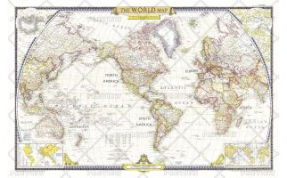
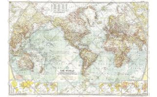
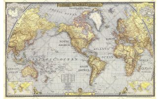 World Map - Published 1943
National Geographic published this classic world map in December 1943, in the midst of WWII. Compared to many of the other world maps by the National Geographic Society, this one had a decidedly dark cast, possibly a reflection of the tone of discouragement felt by many as the War continued on. A perfect companion to the World maps of 1951 and 1970.
Learn MorePrice from $42.99 -
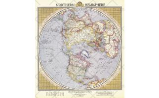 Northern Hemisphere - Published 1946
This colorful and unique map of the Northern Hemisphere appeared in National Geographic Magazine in February 1946 and features airline distances and U.S. air bases. European boundaries are shown as they were prior to Germany's invasion of Poland, and Russian boundaries reflect treaties and claims as of December 1, 1945.
Learn MorePrice from $30.99 -
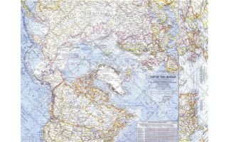
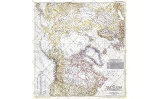 Top of the World - Published 1949
In the October 1949 issue of National Geographic, there were five articles related to polar exploration. The Top of the World map, first published in October of 1949, offers a truly unique view that features the Arctic Polar Region at its center. This beautiful map is both a cartographic masterpiece and a fresh look at the world.
Learn MorePrice from $36.99 -
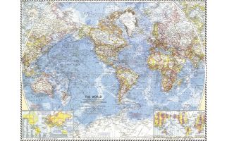
 World - Published 1951
The first World Map published by National Geographic following WWII, this classic is a perfect companion to the World Map published in December 1943. The brightness of this map communicates the optimism following WWII, with an inset showing the United Nations, along with a list of the nations who had joined as of December 1951.
Learn MorePrice from $45.99 -
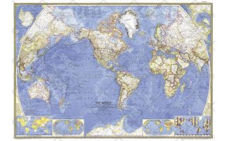
 World - Published 1957
This National Geographic classic is a perfect companion to the World Maps published in December 1943 and December 1951. A cartographic masterpiece, this 1955 map combines a clean, light style with tremendous attention to detail--both on land an in the oceans.
Learn MorePrice from $45.99 -
 World - Published 1960
The National Geographic 1960 World map was published in the midst of sweeping changes in Africa, as many countries gained their independence. This map shows all the changes that had been made as of September, 1960, when the map went to press. Bright boundaries highlight international borders, and the map features extrordinary detail on land and in the oceans. A perfect map for anyone interested in the changes from colonialism to independent rule in Africa.
Learn MorePrice from $30.99 -
 World - Published 1965
This stunning world map contains beautiful colors and the distinct National Geographic cartographic style, as well as detailed ocean bathymetry and information about ocean currents. Published in February 1965 as a companion to the article "Four-Ocean Navy in the Nuclear Age."
Learn MorePrice from $45.99 -
 Top of the World - Published 1965
In the mid 1960s, the USSR and US were in the midst of a cold war, in which each nation was acutely aware of its proximity to the other. This map offers a truly unique view that features the Arctic Polar Region at its center, as well as the "Early Warning Lines" for the United States in case of imminent nuclear attack from the USSR. Published in November of 1965.
Learn MorePrice from $30.99 -
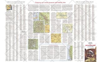 Enjoying Our Scenic Treasures and Historical Sites - Published 1966
A supplement to the Vacationlands of the United States and Canada map, this map includes tips on vacationing and maps of some popular sites. Published in July 1966, it contains information on the variety of scenic and historical sites, from the lure of Indian lands and places where wildlife roam to landmarks of city and industry.
Learn MorePrice from $39.99 -
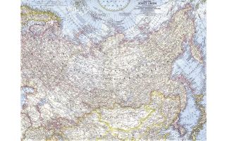 Eastern Soviet Union - Published 1967
This map of the eastern portion of the Soviet Union features many physical and political details, including the country's boundaries in 1938 and the northern limits of wooded country. Published in March 1967 with the article "Siberia: Russia's Frozen Frontier."
Learn MorePrice from $30.99 -
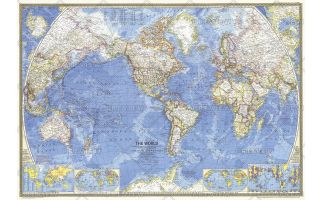 World - Published 1970
A great map is as much a reflection of its time in history as its beautiful craftsmanship. This map presents the world in classic National Geographic style: stunning colors, detailed geographical information, and timely insets. Published in 1970.
Learn MorePrice from $45.99 -
 How Man Pollutes His World - Published 1970
Long before stewardship of the Earth was a popular topic, National Geographic was addressing these thorny issues. "How Man Pollutes His World," publiished in December fo 1970, identified and graphically demonstrated how human activities impact our fragile biosphere. Perfect for any student who wants to learn about how these forces interact.
Learn MorePrice from $45.99