World Maps by Years
Unleash important events, activities, major discoveries, achievements, and other milestones through these world timeline maps. The maps include stories from ancient times, relevant historical sites, regions, and religions. They are ideal wall decor for people who want to stay close to their origin. The maps are printed and published by the world's renowned publishers like National Geographic.
-
 Seeking Our Origins - Published 1997
Published in February 1997 with the Dawn of Humans map and article, this compelling work contains illustrations of the various hominid species discovered. A timeline and other information puts the dawn of early man into perspective.
Learn MorePrice from $33.99 -
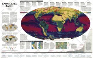 Endangered Earth - Published 1997
We are in a historical transition between a world inherited and one that is profoundly different a global biosphere whose vital functions we have altered. Burgeoning human numbers have placed unprecedented demands on farmland, forests, and other resources, changing the continents green skins of vegetation, as well as the interactions between atmosphere, land, oceans, and living organisms that sustain life on earth. This map shows these interactions and pinpoints growing threats. A wonderful resource for learning more about the delicate balance between development and natural regeneration of the planet.
Learn MorePrice from $48.99 -
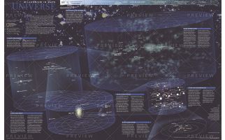 The Universe - Published 1999
Published in October 1999, this fascinating poster contains five maps of our solar system and beyond including: the solar system, our sun's neighborhood, our galactic realm, our local group, and our supercluster. Half of a two-map set in the "Millennium In Maps" series, its companion map entitled "The Milky Way" is also available. Together, the two maps present a striking portrait of the universe as we know it and a hint at what might lie beyond.
Learn MorePrice from $29.99 -
 Bird Migration Eastern Hemisphere - Published 2004
This map illustrates the incredible journeys that birds undertake in the Americas each year. The migration paths of sixty seven types of birds are shown on a map of the Americas that is overlaid with pathways that their routes, from nesting grounds to wintering areas. Full-color bird paintings by noted illustrator Arthur Singer show each of the sixty seven species.
Learn MorePrice from $33.99 -
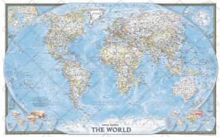 World - Published 2004
Published in November 2004, this political map of the world will look handsome framed and mounted on any wall. Inset maps of the polar regions as well as language families and population density make this map as informative as it is attractive. This map was originally printed as half of a two-map set with "Earth at Night."
Learn MorePrice from $29.99 -
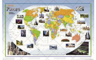 World of Places - Published 2004
This colorful, educational map for kids features large photographs of notable landmarks and places throughout the world.
Learn MorePrice from $35.99 -
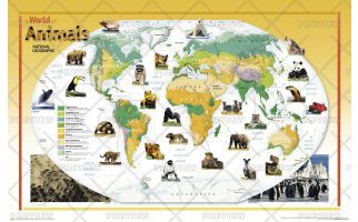 World of Animals - Published 2004
This colorful, educational map for kids features large photographs of animals throughout the world and indicates the areas where they live. The map shows the earth's vegetation zones in beautiful detail.
Learn MorePrice from $35.99 -
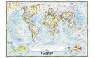 World Classic Spanish - Published 2005
National Geographic's Classic World Map translated to Spanish features the Winkel Tripel projection to reduce distortion of land masses as they near the poles. This creates the most visually accurate representation of Earth's land-masses, versus other projections. The Classic series includes blue oceans, easy-to-read colorful boundaries, and National Geographic's proprietary fonts. Up-to-date and very detailed, with thousands of named places such as countries, oceans, major cities, geographic features. Subtle, easy-to-read border coloring on land. Prevailing winds and ocean currents at sea. Separate insets show the North and South Polar Regions, world vegetation and land use, and world population density.
Learn MorePrice from $42.99 -
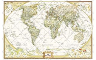 World Executive Spanish - Published 2005
National Geographic's Executive style World Map translated to Spanish features the Winkel Tripel projection to reduce distortion of land masses as they near the poles. This creates the most visually accurate representation of Earth's land-masses, versus other projections. The Classic series includes blue oceans, easy-to-read colorful boundaries, and National Geographic's proprietary fonts. Up-to-date and very detailed, with thousands of named places such as countries, oceans, major cities, geographic features. Antique executive styling. Prevailing winds and ocean currents at sea. Separate insets show the North and South Polar Regions, world vegetation and land use, and world population density.
Learn MorePrice from $39.99 -
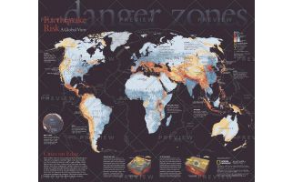 Danger Zones, Earthquake Risk, a Global View - Published 2006
Never before have so many people packed into earthquake-prone cities like Los Angeles, Istanbul, Tokyo, and Lima. Located near the boundaries between Earth's huge, shifting crustal plates, these cities face a rising risk of death and economic disaster from large earthquakes. This eye-catching map reveals the areas most at risk and their populations. Published in April 2006, this map was half of a two-piece set with
Learn MorePrice from $27.99 -
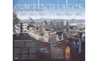 Earthquakes, Living With the Threat - Published 2006
Published in April 2006 as half of a two-piece set with "Danger Zones: Earthquake Risk, A Global View," this remarkable poster demonstrates the damage done to buildings, highways, high-rises, and other structures within a city when plates shift. It also reveals how strict construction standards and new innovations help hold things together when earthquakes strike.
Learn MorePrice from $27.99 -
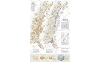 A World Transformed - Published 2007
This revealing pair of maps show the dramatic differences in Native-American and European populations along the eastern coast of North America in 1491 and 1650. Population graphics reveal changes in population from 1500 to 1800. Published in May 2007, this map represents half of a two-map set. Its companion map, "1607: When Cultures Collide," is also available.
Learn MorePrice from $33.99