World Maps by Years
Unleash important events, activities, major discoveries, achievements, and other milestones through these world timeline maps. The maps include stories from ancient times, relevant historical sites, regions, and religions. They are ideal wall decor for people who want to stay close to their origin. The maps are printed and published by the world's renowned publishers like National Geographic.
-
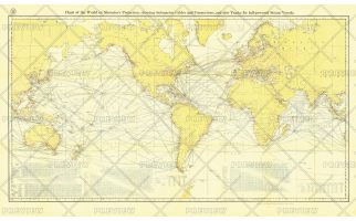 Chart of the World on Mercator's Projection - Published 1905
Submarine cables have played an important part in the development of world-wide communications since the 1850's. National Geographic first charted these cables in 1896. In comparison to that earlier map, this map, published in February 1905 reveals the explosion of communications infrastructure worldwide at the beginning of the last century.
Learn MorePrice from $49.99 -
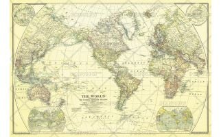 World - Published 1922
This classic world map, published in December of 1922, shows the world's political boundaries established following WWI. This map also shows airplane routes that had been established, as well as railroad routes.
Learn MorePrice from $45.99 -
 World Map - Published 1943
National Geographic published this classic world map in December 1943, in the midst of WWII. Compared to many of the other world maps by the National Geographic Society, this one had a decidedly dark cast, possibly a reflection of the tone of discouragement felt by many as the War continued on. A perfect companion to the World maps of 1951 and 1970.
Learn MorePrice from $42.99 -
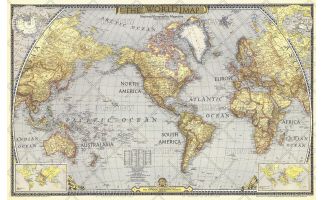
 World - Published 1951
The first World Map published by National Geographic following WWII, this classic is a perfect companion to the World Map published in December 1943. The brightness of this map communicates the optimism following WWII, with an inset showing the United Nations, along with a list of the nations who had joined as of December 1951.
Learn MorePrice from $45.99 -
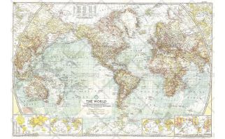 World - Published 1957
This National Geographic classic is a perfect companion to the World Maps published in December 1943 and December 1951. A cartographic masterpiece, this 1955 map combines a clean, light style with tremendous attention to detail--both on land an in the oceans.
Learn MorePrice from $45.99 -
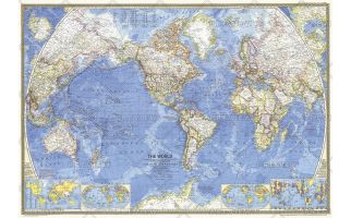
 World - Published 1965
This stunning world map contains beautiful colors and the distinct National Geographic cartographic style, as well as detailed ocean bathymetry and information about ocean currents. Published in February 1965 as a companion to the article "Four-Ocean Navy in the Nuclear Age."
Learn MorePrice from $45.99 -
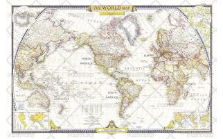
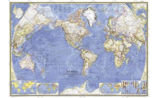
 World - Published 1970
A great map is as much a reflection of its time in history as its beautiful craftsmanship. This map presents the world in classic National Geographic style: stunning colors, detailed geographical information, and timely insets. Published in 1970.
Learn MorePrice from $45.99 -
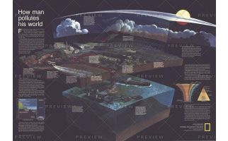 How Man Pollutes His World - Published 1970
Long before stewardship of the Earth was a popular topic, National Geographic was addressing these thorny issues. "How Man Pollutes His World," publiished in December fo 1970, identified and graphically demonstrated how human activities impact our fragile biosphere. Perfect for any student who wants to learn about how these forces interact.
Learn MorePrice from $45.99 -
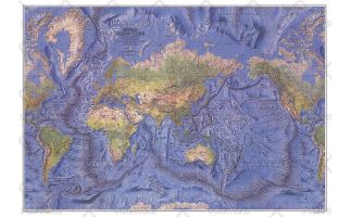 World Ocean Floor - Published 1981
This beautiful physical world map captures the Earth's lands and oceans. Stunning relief shading accentuates the ocean floor, mountain ranges, river valleys, deserts, and continental shelves in amazing detail and beauty. Published in December 1981.
Learn MorePrice from $45.99 -
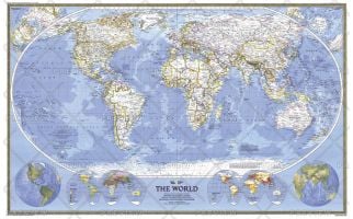 World - Published 1988
This world map combines the classic National Geographic cartographic style with several stunning inset maps to provide a comprehensive look at our planet. Insets include Eastern and Western Hemisphere physical geography, Religions of the World, and Population maps. Published on the National Geographic centennial in December 1988 as a companion to the article "Earth '88: Will We Mend Our Earth?"
Learn MorePrice from $42.99 -
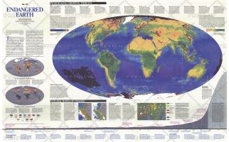 Endangered Earth - Published 1988
This amazing map introduces the issues and challenges surrounding our Endangered Earth as we navigate a historical transition between a world inherited and one profoundly different -- a global biosphere whose vital functions we have altered. Published in December 1988, on the 100th anniversary of the National Geographic Society.
Learn MorePrice from $48.99 -
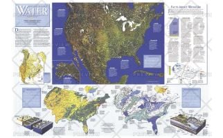 Water Precious Resource - Published 1993
The "Water: Precious Resource" map contains a wealth of information on surface water, ground water, water pollution, and water usuage. This map was published in National Geographic in November 1993 in a special issue devoted to water. A map of the United States also accompanied it.
Learn MorePrice from $48.99