Vancouver Postal Code Map
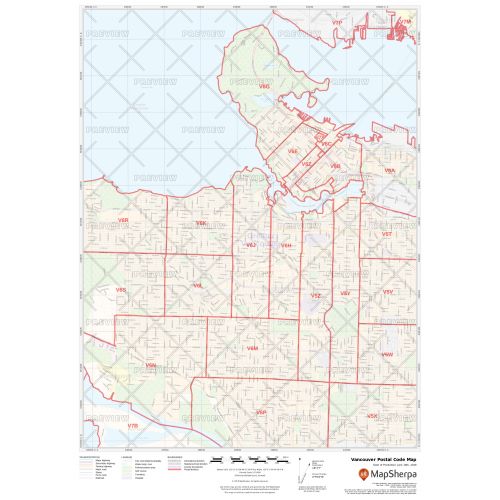
The Vancouver postal code map shows the postal code areas divided using clear boundaries. The detailed base map features information about political boundaries, place names, highways, major parks, conservation areas, and points of interest. You can use this map for quick reference of infrastructures & other street details like interchanges, weigh stations and tolls. It is ideal for tracking down delivery service areas, sales territories, and catchment areas.
You can also customize this map around your preferred location by clicking on 'Close Preview'. If you have any questions, reach out to us over the phone (866) 525-2298 or write to us.
Details
Vancouver Postal Code Map
You can view the political boundaries, place names, highways, major parks, and conservation areas, and other points of interest on this Vancouver postal code map. It is also helpful for a quick reference of infrastructures & other street details like interchanges, weigh stations and tolls. The information on this map can be used in tracking down delivery service areas, sales territories, and catchment areas. Moreover, it assists in providing up-to-date information & is suitable to create multiple maps from city to county scales or anywhere in between.
The customizable base map allows you to create a map centered around your preferred location. You can do this by clicking on 'Close Preview' and then search for the location on the map. Use the drag and drop arrows and zoom buttons to define the print area. You can preview your map with all the details of the final print but at a much lower quality. The final map is available in high quality in various sizes and finishing materials.
About Vancouver
Vancouver is a coastal seaport city in western Canada, located in the Lower Mainland region of British Columbia. It is one of the most ethnically and linguistically diverse cities in Canada and has been consistently named as one of the top five worldwide cities for livability and quality of life.
The city is one of the nation's largest industrial centers and has Canada's largest and most diversified port. Scenic location makes it a major tourist destination with over 10.3 million people visiting Vancouver in 2017. Apart from this, Vancouver is ranked as the second-most unaffordable city in the world. For which the city has adopted various strategies to reduce housing costs, including cooperative housing, legalized secondary suites, increased density, and smart growth.
Vancouver Postal Codes
Vancouver Postal Code is a six-character string that forms part of a postal address in Canada. The code is alphanumeric and is written in a format of ANA-NAN. These postal codes in Vancouver are helpful in finding the exact mailing address. The first 3 characters are called the forward sortation area and are used to identifies the province or territory, distinguish between urban and rural area, and to more precisely locate a geographic district. The FSA of Vancouver ranges from V5K to V6T, V6Z, and V7X to V7Y.
You can use these postal codes to:
1. Locate the nearest postal outlet.
2. Identify your federal riding and member of parliament.
3. Find the nearest bank branches and ATMs as most Canadian banks also have online tools that use postal codes.
More Information
| SKU | ecfe74dcf99c2bec1d4450323d39fec2-Vancouv-P-BC |
|---|---|
| Map Specification | Max Print Scale - 1:15,000 Min Print Scale - 1:2,000,000 Optimal Print Scale - All |
| Publisher Name | MapSherpa |
Reviews
{{title}}
{{detail}}