Manitoba & Saskatchewan Wall Map
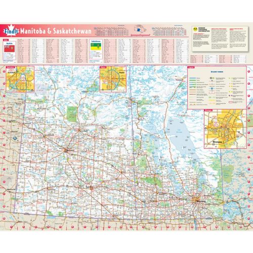
This colorful, easy-to-read province Manitoba & Saskatchewan road map detailed identifies all major thoroughfares, secondary roads, freeway interchanges, rest areas, distance markers, landmarks, recreational areas, and more. Shaded relief on the province map provides a three-dimensional sense of Manitoba & Saskatchewan's topography. Detailed city inset maps of Regina, Saskatoon and Winnipeg are based on the latest street information from our cartographic experts. The map also includes the latest border crossing information. A city index makes it simple to locate even the smallest town.
Details
Manitoba Saskatchewan Road Map
This colorful, easy-to-read province map of Manitoba & Saskatchewan identifies all major thoroughfares, secondary roads, freeway interchanges, rest areas, distance markers, landmarks, recreational areas, and more. Shaded relief on the province map provides a three-dimensional sense of Manitoba & Saskatchewan's topography. Detailed city inset maps of Regina, Saskatoon and Winnipeg are based on the latest street information from our cartographic experts. The map also includes the latest border crossing information. A city index makes it simple to locate even the smallest town.
More Information
| SKU | globeturner-GT075_PR_MBSK_16-1 |
|---|---|
| Flat Size | 17.75 x 21.75 in |
| Publication Date | 2016 |
| Publisher Name | Globe Turner |
Reviews
{{title}}
{{detail}}