Nunavut
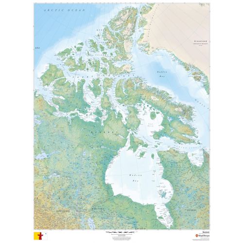
This beautiful map shows physical and political features for Nunavut and surrounding areas. Relief shading and the use of different colours by height above sea level are both informative and attractive.
Details
Nunavut Map
This detailed map of Nunavut shows physical and political features for Nunavut and surrounding areas. Relief shading and the use of different colours by height above sea level are both informative and attractive.
Facts and Figures:
| Area Covered | 1,877,778.53 km2 |
| Latlong Coordinates | 70.2998° N, 83.1076° W |
| Capital | Iqaluit |
| Population | 35,944 |
| Postal Code | X |
| Nearby Cities/States | Arviat, Baker Lake, Cambridge Bay, Gjoa Haven, Cape Dorset, Igloolik, Kugluktuk, Pangnirtung,etc. |
| Popular Places | Auyuittuq National Park, Mount Thor, Beechey Island, Quttinirpaaq National Park, Lancaster Sound, Mount Asgard, Ukkusiksalik National Park, Cumberland Sound, Fury and Hecla Strait, Boothia Peninsula, etc. |
| Economy | Nunavut's economy is Inuit and Territorial Government, mining, oil gas mineral explorarion, arts crafts, hunting, fishing, whaling, tourism, transportation, education, housing, military and research. People of Nunavut primarily rely on diesel fuel to run generators and heat homes, with fossil fuel shipments. |
More Information
| SKU | dmsg-rel-NU-1 |
|---|---|
| Map Scale | 1:3,200,000 |
| Flat Size | 36 x 48 in |
| Publication Date | 2018 |
| Publisher Name | MapSherpa |
Reviews
{{title}}
{{detail}}
No reviews yet ...
Have an opinion? Help others decide. Share your knowledge about this product by submitting a review.
{{/items}}
{{#previousPage}}
Previous Page
{{/previousPage}}
{{#load-more-src}}
Next Page
{{/load-more-src}}
★★★★★
★★★★★