Northern Canada Wall Map in English & French - Large
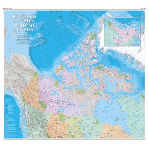
This is a bilingual Northern Canada map. The vast Canadian geography north of approximately 50° latitude is depicted on the map Northern Canada / Nord du Canada. The 1:4 000 000 scale provides a detailed regional base of the north. The map shows the three territories, the northern areas of the provinces, and adjacent areas of Russia, Alaska, and Greenland. The surveyed locations of the Magnetic North Pole are mapped from 1831 to 2011. An inset of the Labrador coast shows the cultural connection of Nunatsiavut to the Inuit of Nunavut.
Details
This is a bilingual Northern Canada map. The vast Canadian geography north of approximately 50° latitude is depicted on the map Northern Canada / Nord du Canada. The 1:4 000 000 scale provides a detailed regional base of the north. The map shows the three territories, the northern areas of the provinces, and adjacent areas of Russia, Alaska, and Greenland. The surveyed locations of the Magnetic North Pole are mapped from 1831 to 2011. An inset of the Labrador coast shows the cultural connection of Nunatsiavut to the Inuit of Nunavut.
More Information
| SKU | nrcan-MCR0036-1 |
|---|---|
| Map Scale | 1:4,000,000 |
| Flat Size | 48 x 44 in |
| Publication Date | 2012 |
| Publisher Name | Natural Resources Canada |
Reviews
{{title}}
{{detail}}