New York, New York Wall Map
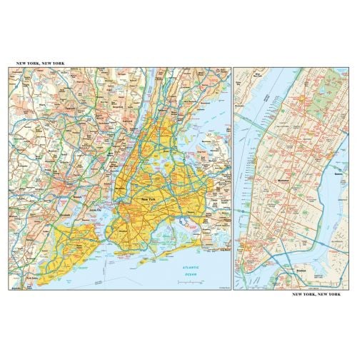
This detailed reference map combines two maps in one - a regional map of New York that includes all five boroughs and northeastern New Jersey plus a street-level map of Midtown and Lower Manhattan. The regional map - including all of Manhattan, Brooklyn, Queens, Bronx, and Staten Island - shows the area's cities and towns, highways and roads, and a variety of points of interest. The inset map of Midtown and Lower Manhattan shows highways, streets, parks, landmarks, and other points of interest. The Financial District, Little Italy, Greenwich Village, the Theater District and the areas around the southern half of Central Park are among the neighborhoods shown on this map.
Details
This detailed reference map combines two maps in one - a regional map of New York that includes all five boroughs and northeastern New Jersey plus a street-level map of Midtown and Lower Manhattan. The regional map - including all of Manhattan, Brooklyn, Queens, Bronx, and Staten Island - shows the area's cities and towns, highways and roads, and a variety of points of interest. The inset map of Midtown and Lower Manhattan shows highways, streets, parks, landmarks, and other points of interest. The Financial District, Little Italy, Greenwich Village, the Theater District and the areas around the southern half of Central Park are among the neighborhoods shown on this map.
More Information
| SKU | globeturner-GT018-CIT-NYC-16-1 |
|---|---|
| Flat Size | 21.75 x 14.5 in |
| Publication Date | 2016 |
| Publisher Name | Globe Turner |
Reviews
{{title}}
{{detail}}