Australia Classic
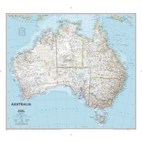
One of the most authoritative Australia map features thousands of place names (including primary and secondary towns), accurate boundaries, aboriginal lands, parks, and protected areas, infrastructure, and relief. You can also view the coverage of Tasmania, the Coral Sea Islands, and the Great Barrier Reef.
Details
Australia Map
This Australia map is ideal for business and referential purposes. You can find thousands of place names (including primary and secondary towns), accurate boundaries, aboriginal lands, parks, and protected areas, infrastructure, and relief on this map.
The map highlights the major states and territories of Australia namely:
- New South Wales- It comprises of Blue Mountains, Central Coast, Central West, Greater Western Sydney, New England, South West Slopes, the city of Sydney, and much more.
- Northern Territory- Comprising of Arnhem Land and Central Australia.
- Queensland- Comprises of Brisbane, Bundaberg, Coral Coast and Country, Capricorn, Gold Coast, Townsville, North Queensland, Whitsunday and much more.
- South Australia- Comprising Adelaide Plains, Barossa Valley, Copper Triangle, Kangaroo Island, Limestone Coast, and much more.
- Tasmania- It includes Central Highlands, Midlands and West Coast.
- Victoria- Comprising Gippsland, The Grampians, The Mallee, Melbourne, The Victorian Alps, Western District, and much more.
- Western Australia- Comprising Gascoyne, Great Southern, Kimberley, Mid West, Perth, Pilbara, Cocos Islands, and much more.
You can buy this Australia map in a selection of finishing materials like paper, matte plastic, and laminated.
More Information
| SKU | ngmaps-RE00620002-1 |
|---|---|
| Map Scale | 1:6,413,000 |
| Flat Size | 30.5 x 27.25 inches |
| Publication Date | 2014 |
| Publisher Name | National Geographic |
Reviews
{{title}}
{{detail}}
No reviews yet ...
Have an opinion? Help others decide. Share your knowledge about this product by submitting a review.
{{/items}}
{{#previousPage}}
Previous Page
{{/previousPage}}
{{#load-more-src}}
Next Page
{{/load-more-src}}
★★★★★
★★★★★