Johnson Map of the World on Hemisphere Projection (1862)
1862 hemisphere map of the World by American map publisher Alvin Jewett Johnson. Full title: Johnson's Western Hemisphere - Johnson's Eastern Hemisphere
Details
About the Johnson's World map with hemispheres
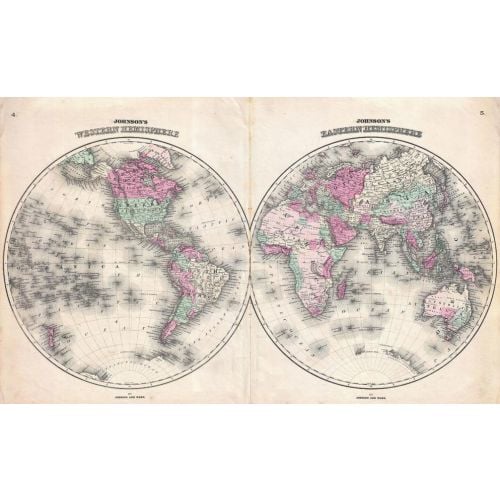
The 1862 published world map with hemispheres is made by American map publisher Alvin Jewett Johnson. This is a dated map made on a paper base that gives it an original map print look. Western and Eastern hemispheres are shown on the map with political features like countries, boundaries, labelled with names and shown in subdued colors.
The map offers a fascinating snapshot of the world during a period of rapid globalisation and discovery. Africa is largely “unexplored” though Lake Uniamesi, something that may be taken for an embryonic form of Lake Victoria, Lake Tanganyika or both, does appear. This curious lake, supposedly identified by Speak, was frequently written of in mid century missionary reports as the source of several important African river systems including the Congo. The Antarctic continent is shown only sketchily, representing the relatively primitive state of Antarctic exploration in 1862. Published by A. J. Johnson and Ward as plate numbers 4 and 6 in the 1862 edition of Johnson’s New Illustrated Family Atlas. This is the first edition of the Johnson’s Atlas to bear the Johnson & Ward imprint.
This beautiful and vintage world map can be a great addition to office walls and home. It adds a classy touch with its excellent composition of colors and cartography. You can buy the map in paper, matte plastic and lamination finish. This 1862 hemisphere map of the World by American map publisher Alvin Jewett Johnson. Full title: Johnson's Western Hemisphere - Johnson's Eastern Hemisphere
More Information
| SKU | artokoloro-AM-170829-1821-1 |
|---|---|
| Flat Size | 20.75 x 12.75 in |
| Publication Date | 1862 |
| Publisher Name | Artokoloro |
Reviews
{{title}}
{{detail}}