Map Showing Location of Panama Canal 1899-1902 - Published 1905
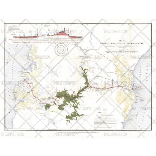
The "Map Showing Location of Panama Canal, as Recommended by the Isthmian Canal Commission of 1899-1902" is a unique historical piece published in October 1905 with three articles on canals. One of the largest engineering projects ever undertaken, the famed canal linking the Atlantic and Pacific oceans was completed in 1914. This map makes a fine companion for the "Birds-eye View of the Panama Canal" map printed in 1912.
Details
The "Map Showing Location of Panama Canal, as Recommended by the Isthmian Canal Commission of 1899-1902" is a unique historical piece published in October 1905 with three articles on canals. One of the largest engineering projects ever undertaken, the famed canal linking the Atlantic and Pacific oceans was completed in 1914. This map makes a fine companion for the "Birds-eye View of the Panama Canal" map printed in 1912.
More Information
| SKU | ngmaps-HM19051000-1 |
|---|---|
| Flat Size | 34.5 x 26.5 in |
| Publication Date | 1905 |
| Publisher Name | National Geographic |
Reviews
{{title}}
{{detail}}