Mexico Classic
Details
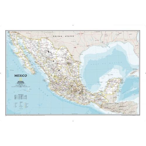
Mexico Wall Map
This Mexico wall map features thousands of place names, accurate political boundaries, national parks including Cumbres de Monterrey National Park, biosphere reserves including El Vizcaino Biosphere Reserve, archeological sites including the ruins of the Yucatán Peninsula, and major infrastructure networks such as roads, canals, ferry routes, and railroads.
The diverse terrain of the country is detailed through accurate shaded relief, coastal bathymetry, and symbolism for water features and other landforms. Elevations of major peaks are expressed in both feet and meters, depth soundings are expressed in fathoms.
Where is Mexico?
Mexico is located directly south of the western part of the United States. It covers almost 2,000,000 square kilometers (770,000 sq mi) and is the fourth largest country in America by total area and the 13th largest independent state in the world.
It is known as Estados Unidos Mexicanos in Spanish and shares borders with six other areas, four of which are land regions and two of which are bodies of water.
Neighboring Places
Mexico shares borders with both land and water bodies. Both of which are listed below:
- The United States to the north
- The Pacific Ocean to the south and west
- Guatemala, Belize, and the Caribbean Sea to the southeast
- The Gulf of Mexico to the east
You can buy separate maps of these places by clicking on their names above.
More Information
| SKU | ngmaps-RE00602295-1 |
|---|---|
| Map Scale | 1:4,370,000 |
| Flat Size | 34.75 x 23 inches |
| Publication Date | 2014 |
| Publisher Name | National Geographic |
Reviews
{{title}}
{{detail}}