Shipwrecks of Delmarva
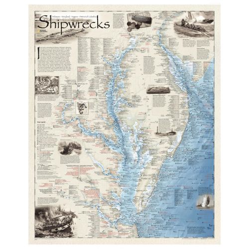
Shipwrecks of the Delmarva shows the location of more than 2,400 wrecks from the waters off the Delaware coast to the waters of the Chesapeake Bay, displayed atop beautiful bathymetric and coastal detail. Each wreck site is symbolized to define the class, type, and name of vessel accompanied by their dates of sinking. Locations of lifesaving stations, lighthouses and lightships, along with navigational beacons are accurately marked. Bathymetric and coastal features are clearly labeled, accompanied by inset maps, captions, and drawings used to highlight unique historical events such as the sinking of the U.S.S. Cumberland, the German U-Boat offensives, and the ghost fleet of Mallows Bay — the largest assemblage of wooden ships in the Western Hemisphere.
Wrecks featured on this map span from the mid-1600s galleons to 20th-century naval ships, those lost in military conflict, foul weather, bloody mutinies, pirate raids, human error, treacherous shoals, and a myriad of other events.
Details
Shipwrecks of the Delmarva shows the location of more than 2,400 wrecks from the waters off the Delaware coast to the waters of the Chesapeake Bay, displayed atop beautiful bathymetric and coastal detail. Each wreck site is symbolized to define the class, type, and name of vessel accompanied by their dates of sinking. Locations of lifesaving stations, lighthouses and lightships, along with navigational beacons are accurately marked. Bathymetric and coastal features are clearly labeled, accompanied by inset maps, captions, and drawings used to highlight unique historical events such as the sinking of the U.S.S. Cumberland, the German U-Boat offensives, and the ghost fleet of Mallows Bay — the largest assemblage of wooden ships in the Western Hemisphere.
Wrecks featured on this map span from the mid-1600s galleons to 20th-century naval ships, those lost in military conflict, foul weather, bloody mutinies, pirate raids, human error, treacherous shoals, and a myriad of other events.
More Information
| SKU | ngmaps-RE01020595-1 |
|---|---|
| Map Scale | 1:414,500 |
| Flat Size | 28 x 35 inches |
| Publication Date | 2011 |
| Publisher Name | National Geographic |
Reviews
{{title}}
{{detail}}