Philippines
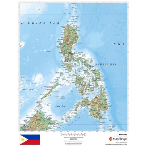
This beautiful map shows physical and political features for the Philippines and surrounding areas. Relief shading and the use of different colours by height above sea level are both informative and attractive.
Details
Flag -
The Philippines national flag is a horizontal flag bicolor with equal bands of royal blue and scarlet, and with a white, equilateral triangleat the hoist.
Country full name - Republic of the Philippines
Important National Days - Philippines Independence Day: 12th June
Provinces - Zambales, Bohol, Siquijor, Cebu, Pangasinan, Cagayan, Quezon,Isabela, Cavite, Antique, Northern, Samar, Bulacan, Tawi-Tawi, Basilan, Quirino, Romblon, Catanduanes, Bukidnon, Aklan, Marinduque, Benguet, Misamis, Oriental, Rizal, La, Union, Ilocos, Norte, Palawan, Nueva, Vizcaya, Mountain, Province, Camarines, Sur, Negros, Occidental, Misamis, Occidental, Dinagat, Islands, Camarines.
Capital City - Manila
Major Cities - Manila, Cebu, Quezon, City, Davao, Pasig, Zamboanga, City, Taguig, Caloocan, Cagayan de Oro, Makati, Bacolod, Antipolo, Pasay, Mandaluyong, Baguio, Puerto
Continent - Asia
Currency - Philippine peso
Primary Languages - English, Filipino
Time-Zone - (GMT+8)
ISO Code - PHL
Country Code - 63
Area Covered - 1300,000sq km
Neighbouring Countries - Taiwan, Malaysia, Vietnam, Cambodia, Laos
National Mapping Agency - National Mapping and Resource Information Authority
Did you know? - The country is the second largest archipelago in the world and is made up of 7107 islands. Phillippines was the first country in Southeast Asia to gain independence after World War II in 1945.
Map of Philippines
Map of Philippines by MapSherpa features physical and political detailing with clear demarcation of countries, international provinces, towns & cities. Relief shading and different colours represent the height above see level. A closer look at the map gives details about hundreds of place names, capitals, boundaries and more. Diverse land area is also represented using terrain topography. The archipelagic country in Southeast Asia is composed of about 7,641 islands and its economy is the 34th largest in the world.
The annual national holiday in the Philippines is observed to commemorate the independence of the Philippines from Spain.
More Information
| SKU | dmsg-rel-philippines-1 |
|---|---|
| Map Scale | 1:4,000,000 |
| Flat Size | 17 x 22 in |
| Publication Date | 2018 |
| Publisher Name | MapSherpa |
Reviews
{{title}}
{{detail}}