Republic of the Congo
Details
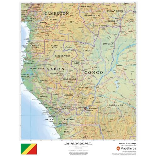
Republic of the Congo Map
Republic of the Congo map shows detailed political and physical features of the country. It uses relief shading and different color hues to depict the height above sea level. You can view all major cities including the capital city, Brazzaville, and other surrounding places on the map. A small flag of the country is also featured at the bottom of the map. This flag has a yellow diagonal band in the middle that divides the green upper triangle and red lower triangle.
You can buy this high-quality map in a selection of finishes that include paper, matte plastic, and laminate.
Where is the Republic of the Congo?
The Republic of the Congo also called the Congo is a country located on the western coast of Central Africa. It lies in the central-western part of sub-Saharan Africa, along the Equator, between latitudes 4°N and 5°S and longitudes 11° and 19°E.
Brazzaville, the capital city, is located on the Congo River in the south of the country.
Major Cities in the Congo
Below is a list of the largest cities in the country by population. You can buy maps of all these cities by clicking on their respective names. Also, all these city maps are customizable, i.e you can center them around your preferred location and order them in various sizes and finishes.
Neighboring Places
The Congo shares its border with a number of other countries. You can find maps of all these places separately by clicking on their name below:
More Information
| SKU | dmsg-rel-congo-1 |
|---|---|
| Map Scale | 1:3,000,000 |
| Flat Size | 17 x 22 in |
| Publication Date | 2018 |
| Publisher Name | MapSherpa |
Reviews
{{title}}
{{detail}}