Tasmania State Map
Details
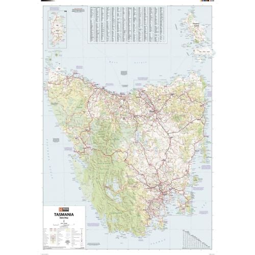
Tasmania Australia Map
This Tasmania Australia map is a great wall map for your homes and offices. You can view major towns, cities, and secondary roads on this map. All parks and water bodies are also highlighted in green, brown and blue color tones.
An inset map of King Island is featured on the map with an index to towns and places and a map legend. Roads highlighted on the map includes distances between towns, route numbering, national parks & reserves.
You can buy this detailed map in a selection of finishing materials that include paper, matte plastic, and laminate.
Where is Tasmania?
The island state of Australia is located 240 km (150 mi) to the south of the Australian mainland, separated by the Bass Strait. It is the only Australian state that is not located on the Australian mainland.
Major Cities in Tasmania
Five largest cities in the state by population are:
You can buy maps of these cities by clicking on their names above. These city maps are customizable and you can center them around your preferred location.
More Information
| SKU | hema-ZEOTAS02F-1 |
|---|---|
| Map Scale | 1:480,000 |
| Flat Size | 28.25 x 40 in |
| Publication Date | 2013-01-01 |
| Publisher Name | Hema Maps |
Reviews
{{title}}
{{detail}}