Classic USA Wall Map
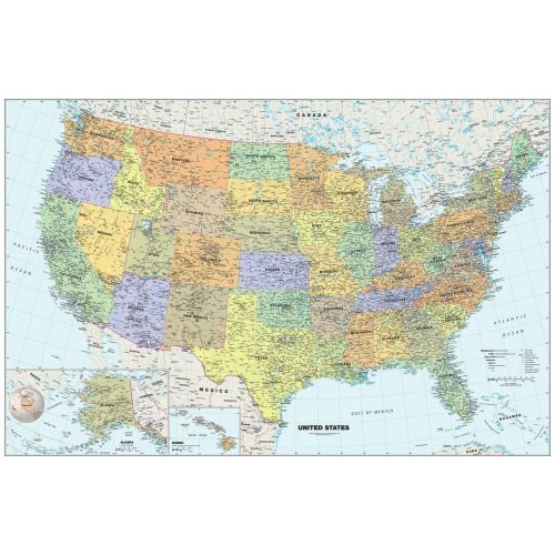
Perfect for home, business, or school, this Classic USA Wall Map combines warm, attractive colors with high-detailed cartography. Details on this United States Wall Map include: state boundaries and capitals along with other major cities and towns; major physical features such as mountain ranges and major mountain peaks; major water features such as oceans, seas, gulfs, and rivers; the Interstate highway system and other major roads; and all National Parks as well as other large National Park Service sites. Special features include traditional, blue-colored oceans and a white decorative border. This map of the United States uses the Albers Equal Area projection.
Details
Details on the Map
The large map poster of the USA is a political map showing the federal divisions. The map shows the boundaries of each state with the placement of provincial capitals and major cities. The map details include important physical attributes of the country, national parks and time zone boundaries. State and interstate highway system also form a part of the framework.
Each state is demarcated with a specific color and line margins. States and provincial capitals are dotted and named in bold readable fonts. A large number of major cities and towns are type faced on the map to show their location. US Highway system and interstate roads are clearly labeled and numbered.
Physical features of the country include mountain ranges, intricate river systems and deserts. The map shows the oceans and gulfs surrounding the country and includes an inset map of two other states - Alaska and Hawaii.
This political representation of the USA is projected on a warm color base and provides stunning imagery. Comprehensive detailing makes it a great map for reference in educational institutions, libraries, embassies, and any other space.
-
Locations on the Map
The political division of all 50 states is clearly demarcated with color codes adding a warm contrast. State and provincial capitals along with some major cities and towns are named and dotted for quick reference.
International Boundaries
Parts of Canada in the north and Mexico in the south can be effortlessly placed. Cuba, Bahamas and some parts of Russia are also visible on the map.
Physical Attributes
Significant terrain features like mountain ranges, rivers, desert regions and the five important lakes are captioned and can be easily spotted. Parts of the Canadian Shield are also visible on the map.
Oceans Gulfs
The Atlantic Ocean in the east and Pacific ocean in the west are named with large fonts and add a lovely blue backdrop to the map frame. The Gulf of Mexico, Gulf of California, the Gulf of Maine and the Gulf of Alaska can also be located with ease.
Route Maps
The map shows an integrated network of roads and highways major and limited-access roads. Highways are numbered and highlighted with thread markings for quick reference.
Time Zone Boundary
The map projects the 4 standard time zone boundaries in the contiguous state of the US and also the respective time zones in Alaska and Hawaii.
Insets
Alaska and Hawaii are marked in separate insets showing major cities and towns along with parts of Russia. A globe locator added to the inset indicates the continental placement of the USA.
Grid
Important Latitudes and Longitudes are outlined with ,specific degrees. The tropic of Cancer is also marked in the map
Map Key
An informative key table lays out details about highways, parks, mountain peaks, time zone, continental divides and more.
Map Scale and Projection
The map is on a scale of 1:4,000,000. The Insets of Alaska and Hawaii are also based on the same scale. Albers Equal Area projection is used in the map for minimal distortion.
Uses
With meticulous detailing the US Map with State names is perfect for any kind of geographical reference in educational institutions, offices, libraries and homes. With a unique contrast of colors and a decorative border, this map instantly adds a spark to any dull wall.
Other Products
Wide ranges of products are available for perusal
More Information
| SKU | globeturner-GT001-CLA-USA-16-1 |
|---|---|
| Map Scale | 1:4,000,000 |
| Flat Size | 50 x 33 in |
| Publication Date | 2016 |
| Publisher Name | Globe Turner |
Reviews
{{title}}
{{detail}}