Brazil Executive
Details
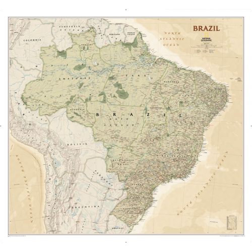
Brazil Map
This executive-style Brazil map shows political boundaries, major highways and roads, cities and towns, airports, and other geographic details. Thousands of place-names and exact borders are carefully researched by National Geographic's map researchers and editors ensuring the utmost accuracy.
It highlights Brazil's 26 states and 1 federal district, plus the coastal islands that makeup Fernando de Noronha National Marine Park, Abrolhos National Park, and Arquipelago dos Abrolhos. You can buy this high-quality map in a selection of finishing materials like paper, matte plastic, and laminate.
About Brazil
Country's full name- Federative Republic of Brazil
Important National Days- September 7, Independence Day
Capital- Brasília
Major Cities- São Paulo, Rio de Janeiro, Belo Horizonte, and Recife
Continent- South America
Currency- Real
Time-Zone- UTC−2 to −5
ISO CODE- BR
Country Code- +55
Area Covered- 3,287,956 sq mi
Neighbouring Places- Uruguay, Argentina, Paraguay, Bolivia, Peru, Colombia, Venezuela, Guyana, Suriname and French Guiana
More Information
| SKU | ngmaps-RE01020611-1 |
|---|---|
| Map Scale | 1:5,000,000 |
| Flat Size | 41 x 38 inches |
| Publication Date | 2011 |
| Publisher Name | National Geographic |
Reviews
{{title}}
{{detail}}