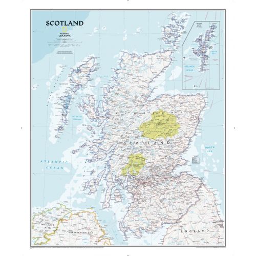
Scotland Classic
The classic-style Scotland wall map is one of the largest and most detailed maps available. Includes hundreds of named places including primary and secondary towns, counties, political boundaries, infrastructure, and selected historical sites. Shows Scotland in its entirety including the Highlands, Southern Uplands, Isle of Skye, Outer Hebrides, Inner Hebrides, Orkney Islands and the Shetland Islands (shown in an inset map). The nine political council areas of Scotland are also clearly identified.
Details
Flag -
Important National Days - National Day of England: St. George's Day: March 1
Provinces - London, The Southeast, Hampshire, Dorset, and, Wiltshire, Oxfordshire, the Cotswolds, and around Bristol Bath and Somerset, Devon, and, Cornwall, East, Anglia, The West Midlands and the Peak District,
Capital City - London
Major Cities - Edinburgh, Glasgow, Dundee, Aberdeen, Stirling, Perth, Paisley, St Andrews, Dunfermline, Greenock, East, Kilbride, Elgin, Kilmarnock, Falkirk, Dumfries,, Glenrothes, Coatbridge,, Airdrie,, Arbroath, Kirkwall, Fort, William, Motherwell, Irvine, Dumbarton, Stornoway, Peterhead, Prestwick, Bannockburn, Oban, Johnstone, Alloa, Midlothian, Melrose, Bathgate, Galashiels, Lerwick, Dunbar, Hamilton, Linlithgow.
Continent - Europe
Currency - Pound sterling
Primary Languages - English, Scots, Scottish, Gaelic
Time-Zone - (GMT)
ISO Code - GBR
Country Code - 44
Area Covered - 80,077sq km
Neighbouring Countries - South of Norway, West of Belgium, North of England and East of Ireland.
Did you know? - Scotland is home to the world’s tallest hedge & it has approximately 790 islands. The shortest commercial flight in the world is in Scotland. The country has three officially recognised languages: English Scots and Scottish Gaelic.
Map of Scotland
The classic-style Scotland wall map is one of the largest and most detailed maps available. Includes hundreds of named places including primary and secondary towns, counties, political boundaries, infrastructure, and selected historical sites. Shows Scotland in its entirety including the Highlands, Southern Uplands, Isle of Skye, Outer Hebrides, Inner Hebrides, Orkney Islands and the Shetland Islands (shown in an inset map). The nine political council areas of Scotland are also clearly identified.
Scotland kingdom emerged as an independent sovereign state in the Early Middle Ages and continued to exist until 1707.
More Information
| SKU | ngmaps-RE01020533-1 |
|---|---|
| Map Scale | 1:650,000 |
| Flat Size | 30 x 36 inches |
| Publication Date | 2010 |
| Publisher Name | National Geographic |
Reviews
{{title}}
{{detail}}