Territorial Divisions (1906)
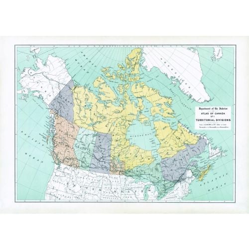
Contained within the 1st Edition (1906) of the Atlas of Canada is a map that shows the territorial divisions of Canada. The map displays 1,922.735 sq. miles of unsettled North West Territories, covering what is now Northern Ontario. In addition to this is the northern half of Quebec, which includes the southern part of Labrador. Manitoba is considerably smaller with its width mainly in the south, but only going a third as far north to the middle of Lake Winnipeg. Using a variety of colours the map emphasizes large proportion of the Dominion in the North West Territories, and well as the other territorial divisions. The boundaries of the Yukon, British Columbia, Alberta, Saskatchewan, New Brunswick, Nova Scotia and Prince Edward Island, is represented as they are found in the present day. Newfoundland is not yet a part of Canada, thus omitted as one of the Canadian provinces.
Details
Contained within the 1st Edition (1906) of the Atlas of Canada is a map that shows the territorial divisions of Canada. The map displays 1,922.735 sq. miles of unsettled North West Territories, covering what is now Northern Ontario. In addition to this is the northern half of Quebec, which includes the southern part of Labrador. Manitoba is considerably smaller with its width mainly in the south, but only going a third as far north to the middle of Lake Winnipeg. Using a variety of colours the map emphasizes large proportion of the Dominion in the North West Territories, and well as the other territorial divisions. The boundaries of the Yukon, British Columbia, Alberta, Saskatchewan, New Brunswick, Nova Scotia and Prince Edward Island, is represented as they are found in the present day. Newfoundland is not yet a part of Canada, thus omitted as one of the Canadian provinces.
More Information
| SKU | nrcan-294049-1 |
|---|---|
| Map Scale | 1:12,500,000 |
| Flat Size | 24 x 17 in |
| Publication Date | 1906 |
| Publisher Name | Natural Resources Canada |
Reviews
{{title}}
{{detail}}