Yukon
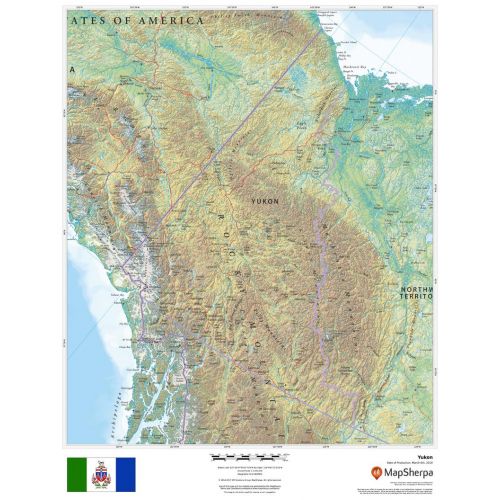
This beautiful map shows physical and political features for the Yukon surrounding areas. Relief shading and the use of different colours by height above sea level are both informative and attractive.
Details
Yukon Territory Map
This beautiful Yukon map shows physical and political features for the Yukon and surrounding areas. Relief shading and the use of different colours by height above sea level are both informative and attractive.
Facts and Figures: Yukon Canada Map
| Area Covered | 474,712.68 km2 |
| Latlong Coordinates | 64.2823° N, 135.0000° W |
| Capital | Whitehorse |
| Population | 35,874 |
| Postal Code | Y |
| Nearby Cities/States | Oklahoma, Tulsa, Wichita, Plano, Garland, Fort Worth, Arlington, Dallas, etc. |
| Popular Places | Kluane National Park and Reserve, Mount Logan, SS Klondike, Sign Post Forest, Miles Canyon Basalts, Emerald Lake, Takhini Hot Springs, MacBride Museum of Yukon History, Lake Laberge, Vuntut National Park, etc. |
| Economy | Yukon's historical major industry was mining. Manufacturing, including furniture, clothing, and handicrafts, follows in importance, along with hydroelectricity. Today, the government sector is by far the biggest employer in the territory employing approximately 5,000 out of a labour force of 12,500, on population of 36,500. |
More Information
| SKU | dmsg-rel-YT-1 |
|---|---|
| Map Scale | 1:3,000,000 |
| Flat Size | 17 x 22 in |
| Publication Date | 2018 |
| Publisher Name | MapSherpa |
Reviews
{{title}}
{{detail}}
No reviews yet ...
Have an opinion? Help others decide. Share your knowledge about this product by submitting a review.
{{/items}}
{{#previousPage}}
Previous Page
{{/previousPage}}
{{#load-more-src}}
Next Page
{{/load-more-src}}
★★★★★
★★★★★
Related Products
Whitehorse Yukon Map
As low as
$41.99
Northwest Territories
As low as
$33.99
Making of Canada, Yukon and Northwest Territories - Pub...
As low as
$27.99
Boundaries of BC-Yukon-Alaska, Ontario-Manitoba (1906)
As low as
$19.99
British Columbia, Alberta and the Yukon Territory Theme -...
As low as
$29.99