Canada Classic
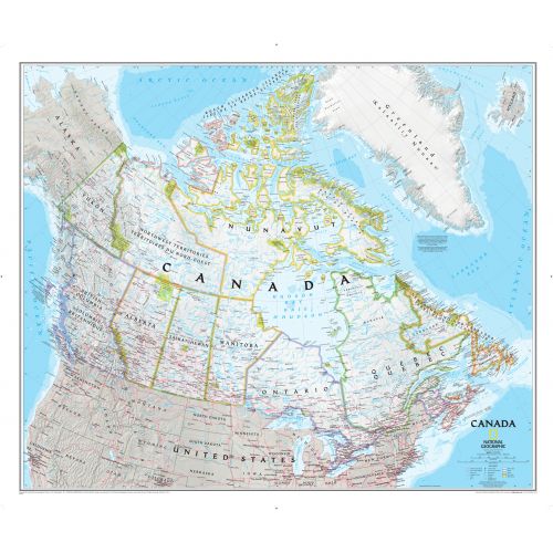
This classic-style map of Canada with provinces and capital cities features thousands of place names, accurate political boundaries, national parks, archeological sites, and major infrastructure networks such as roads, canals, ferry routes, and railroads. Canada's diverse terrain is detailed through accurate shaded relief, coastal bathymetry, and symbolism for water features and other landforms. It depicts Canada and the areas surrounding the Great Lakes. Includes Canadian provinces and US State boundaries.
Details
-
Canada Flag also referred to as the 'Canadian Flag' is the national flag that consists of a red field with a white square at its centre in the ratio of 1:2:1. Also featured in the middle is a stylized, red, 11-pointed maple leaf charged in the centre. The maple leaf is a symbol of Canada, that also symbolizes unity, tolerance, and peace.
Country full name - Dominion of Canada
Important National Days - Canada Day:1st July
Provinces - Ontario, British Columbia, Quebec, Alberta, Nova Scotia, Manitoba, Saskatchewan, New Brunswick, Newfoundland & Labrador, Prince Edward Island
Capital City - Ottawa
Continent - North America
Currency - Canadian Dollar
Primary Languages - English & French
Time-Zone - "UTC−3.5 to −8, Summer (DST), UTC−2.5 to −7"
ISO CODE - CAN
Country Code - 1
Area Covered - 9,984,670 sq km
Neighbouring Countries - USA, Greenland, Alaska, Bermuda (UK)
National Mapping Agency - Natural Resources Canada (NRCan)
Did you know? - Canada is the second largest country in the world. It is also the World's Most Educated Country, which also has more lakes than the rest of the world's lakes combined. Canada has the longest coastline in the world. The U.S. - Canada Border is the longest international border in the world which lacks military defense.
Canada Map
This classic-style political map of Canada with provinces and capital cities features thousands of place names, accurate political boundaries, national parks, archaeological sites, and major infrastructure networks such as roads, canals, ferry routes, and railroads. Canada terrain is detailed through accurate shaded relief, coastal bathymetry, and symbolism for water features and other landforms. It depicts Canada and the areas surrounding the Great Lakes. Includes Canadian provinces and US State boundaries.
Canada is known as the second-largest country in the world in terms of the area covered. The country is a parliamentary democracy, a constitutional monarchy & a highly globalized economy. Being a developed country, Canada has the fifteenth-highest nominal per capita income and its economy is the tenth-largest in the world.
The country is recognized as a middle power for its role in international affairs that has a tendency to pursue multilateral solutions. It shares the world's longest undefended border & is each other's largest business - trading partners. Moreover, it is one of the world's top ten trading nations.
.svg)
The national day of Canada is a federal statutory holiday that celebrates the anniversary of July 1st, 1867 - an effective date of the Constitution Act, 1867 which united the British Empire called Canada. This day is celebrated throughout the country and in various locations around the world.
More Information
| SKU | ngmaps-RE01020527-1 |
|---|---|
| Map Scale | 1:6,400,000 |
| Flat Size | 38 x 32 inches |
| Publication Date | 2011 |
| Publisher Name | National Geographic |
Reviews (1)
{{title}}
{{detail}}