Victoria British Columbia Postal Code Map
The Victoria BC Postal Code map is available in high quality with clear boundaries that divide different postal codes. The map can be customized around the location of your choice that can be your business service area, sales territory, etc. Search for the location on the map and drag the arrows to define the print area. You can preview your map with all the details of the final print. The map is an ideal business tool for planning deliveries, catchment areas, etc.
If you have any questions, reach out to us over the phone (866) 525-2298 or write to us.
Details
Victoria Postal Code Map
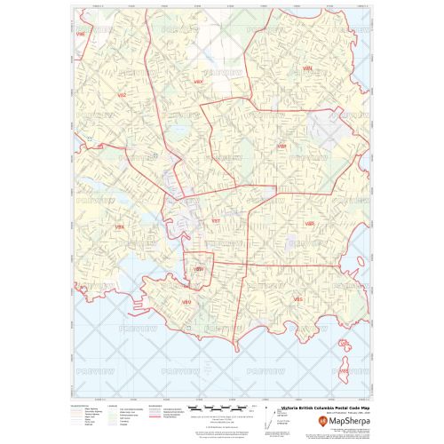
The Victoria BC postal code map shows political boundaries, place names, highways, major parks and conservation areas, and points of interest. You can use this map for quick reference of infrastructures & other street details like interchanges, weigh stations and tolls. The map is ideal for tracking down delivery service areas, sales territories, and catchment areas. Moreover, it also assists in providing up-to-date information & is suitable to create multiple maps from city to county scales or anywhere in between.
You can create multiple maps by customizing this map around your business service area. Search for the location on the map and drag the arrows to define the print area. You can preview your map with all the details of the final print but at a much lower quality. The final map is available in high quality with clear boundaries that divide different postal codes. You also get the option to add a title and select your desired size, orientation, and finishing material.
About Victoria BC
The capital of British Columbia, Victoria is located on the southern tip of Vancouver Island off Canada's Pacific coast. It is the 7th most densely populated city in Canada with 4,405.8 people per square kilometer. The city is named after Queen Victoria of the United Kingdom and, at the time, British North America. It is also known as "The Garden City" and is a popular tourist destination with a thriving technology sector that has risen to be its largest revenue-generating private industry.
About Postal Code
The postal codes in Canada are written in an ANA NAN format, where A is the alphabet and N is a numerical value. The first segment of the code is known as the 'forward sortation area' (FSA) and is used to identify the geographic location of the address. The Forward Sortation Area of Victoria ranges from V8N – V9E.
The second segment is called the 'location delivery unit' (LDU), it represents either a specific address or group of addresses. It can cover an entire city block, all of a high-rise, a small rural community or even a single house.
You can also buy the Canada Postal Code Map, Ontario Postal Code Map, Toronto Postal Code Map, Kitchener Postal Code Map, Cambridge Ontario Postal Code Map.
More Information
| SKU | ecfe74dcf99c2bec1d4450323d39fec2-Victoria_BC |
|---|---|
| Map Specification | Max Print Scale - 1:15,000 Min Print Scale - 1:2,000,000 Optimal Print Scale - All |
| Publisher Name | MapSherpa |
Reviews
{{title}}
{{detail}}