Lesser Slave Lake Map
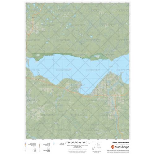
Lesser Slave Lake map uses relief shading to highlight traditional topographic features like elevation contours, landforms, lakes, and rivers along with roads, rails, trails, and park boundaries. The base map shows key points of interest such as campsites, trailheads, and landmarks. You can buy this map in high-quality print in your choice of orientation, size, and finishing material. The map can also be customized around your central location.
If you have any questions, reach out to us over the phone (866) 525-2298 or write to us.
Details
Lesser Slave Lake Map
The Lesser Slave Lake map exhibits beautiful cartography and covers nearby cottages, resorts and other points of interest. It highlights traditional topographic features like elevation contours, landforms, lakes, and rivers using relief shading. The base map shows key points such as campsites, trailheads, and other major landmarks. Other major settlements on the Lesser Slave Lake that can be located on the map are Slave Lake and High Prairie.
You can buy this high-quality Lesser Slave Lake map in your choice of size, orientation, and finishing materials. We also have the option to customize the map around your desired central location. Click on 'Close Preview' to edit the print area.
About Lesser Slave Lake
Lesser Slave Lake in central Alberta is the second largest lake entirely within Alberta boundaries, covering 1,160 km2 (450 sq mi) and measuring over 100 km (62 mi) long and 15 km (9.3 mi) at its widest point. The average depth of the lake is 11.4 m (37 ft) and is 20.5 m (67 ft) at its deepest. And it drains eastwards into the Athabasca River by way of the Lesser Slave River.
Conservation and Development
Lesser Slave Lake is a major flyway for migrating birds and is a popular birdwatching site. Its nearby places like the Lesser Slave Lake Provincial Park also has lakeside camping facilities located along sandy beaches, with some rocky beaches as well. Other than birdwatching, fishing is also popular and legal here. The entire north shore of the lake is protected by other reserves like Hilliard's Bay Provincial Park, Lesser Slave Lake Wildland and Grouard Trail Park Reserve.
Few Indian reserves established at the shores of the lake are:
1. Kapawe'no First Nations Lands 150, 230 and 231 of the Kapawe'no First Nation
2. Sucker Creek 150a of the Sucker Creek Cree First Nation
3. Drift Pile River 150 of the Driftpile First Nation
4. Swan River 150e of the Swan River First Nation
5. Sawridge 150g and h Sawridge Band
Explore many other intriguing lakes in our collection of Canada Lakes Maps. You can also view the Great Lakes maps like Lake Michigan map, Lake Superior map, Lake Erie Map, and Lake Ontario Map.
More Information
| SKU | 9ec2ccde4ea71cd83900cdedf628db72-Slave-L-AB |
|---|---|
| Map Specification | Max Print Scale - 1:15,000 Min Print Scale - 1:2,000,000 Optimal Print Scale - All |
| Publisher Name | MapSherpa |
Reviews
{{title}}
{{detail}}