World Maps by Years
Unleash important events, activities, major discoveries, achievements, and other milestones through these world timeline maps. The maps include stories from ancient times, relevant historical sites, regions, and religions. They are ideal wall decor for people who want to stay close to their origin. The maps are printed and published by the world's renowned publishers like National Geographic.
-
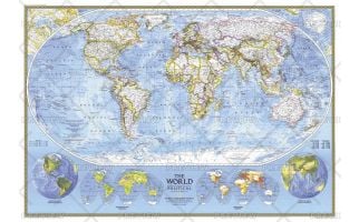 World Political - Published 1994
This political world map continues the long tradition of fine cartography for which National Geographic is known. Published in 1994.
Learn MorePrice from $42.99 -
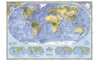 World Physical - Published 1994
This physical world map strikingly captures the lands and oceans of the Earth. See mountain ranges, river valleys, deserts, continental shelves, and ocean floor in amazing detail and beauty. Published in February 1994.
Learn MorePrice from $42.99 -
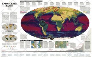 Endangered Earth - Published 1997
We are in a historical transition between a world inherited and one that is profoundly different a global biosphere whose vital functions we have altered. Burgeoning human numbers have placed unprecedented demands on farmland, forests, and other resources, changing the continents green skins of vegetation, as well as the interactions between atmosphere, land, oceans, and living organisms that sustain life on earth. This map shows these interactions and pinpoints growing threats. A wonderful resource for learning more about the delicate balance between development and natural regeneration of the planet.
Learn MorePrice from $48.99 -
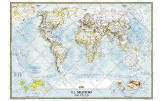 World Classic Spanish - Published 2005
National Geographic's Classic World Map translated to Spanish features the Winkel Tripel projection to reduce distortion of land masses as they near the poles. This creates the most visually accurate representation of Earth's land-masses, versus other projections. The Classic series includes blue oceans, easy-to-read colorful boundaries, and National Geographic's proprietary fonts. Up-to-date and very detailed, with thousands of named places such as countries, oceans, major cities, geographic features. Subtle, easy-to-read border coloring on land. Prevailing winds and ocean currents at sea. Separate insets show the North and South Polar Regions, world vegetation and land use, and world population density.
Learn MorePrice from $42.99 -
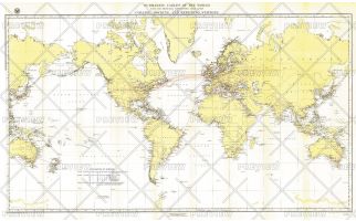 Submarine Cables of the World - Published 1896
Submarine cables have played an important part in the development of world-wide communications since the 1850's. This fascinating map, first develped for the Department of the Navy and published in National Geographic in 1896, shows submarine cables that had been laid, as well as the land-based cable systems that connected to them.
Learn MorePrice from $54.99 -
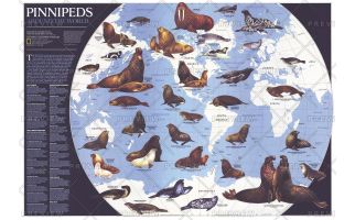 Pinnipeds Around the World - Published 1987
Pinniped means "fin-footed" and refers to seals, sea lions, and walruses. This extraordinary map contains illustrations of the many different species of pinnipeds and interesting facts about where they live, what they eat, and more. Published in April 1987 with the article "Seal and Their Kin," this map also accompanied the map of Antarctica published in the same issue.
Learn MorePrice from $99.99