Top World Maps
Find every bestselling world map from eminent map publishers in one place! Ranging from legacy maps, Pacific centered maps, to the graphic world map, this collection has it all. These maps are a great source for both geographic and political information. Available in various styles like antique, classic, and contemporary they are perfect for home, business, and educational references.
-
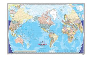
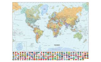 Classic World Wall Map with FlagsPerfect for home, business, or school, this Classic World Wall Map with Flags combines warm, traditional colors with high-detailed cartography. Details on this World Wall Map include: international boundaries and national capitals along with other major cities; major physical features such as mountain ranges, major mountain peaks, island chains, and deserts; major water features such as oceans, seas, gulfs, and rivers; and national flags of each country. Special features include light blue-colored oceans, a white decorative border, and an inset of Antarctica. This map of the world uses the Van Der Grinten projection. The 2020 edition features several city-name changes in Alaska, Angola, South Africa, and Turkmenistan. In addition, the colors of many flags have been altered slightly to reflect the Pantone values recognized by the London Olympic Committee for the 2012 Summer Olympics as each participating country was required to approve their own flag design submitted by the LOC. Learn MorePrice from $54.99
 -
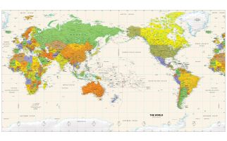 Pacific-Centered World Wall MapPerfect for home, business, or school, this Pacific Ocean-centered World Wall Map combines bright, attractive colors with high-detailed cartography. Details on this World Wall Map include: international boundaries and national capitals along with other major cities; major physical features such as mountain ranges, major mountain peaks, island chains, and deserts; and major water features such as oceans, seas, gulfs, and rivers. Special features include ivory-colored oceans and a white decorative border. This map of the world uses the Miller projection. The 2020 edition features several city-name changes in Alaska, Angola, South Africa, and Turkmenistan. Learn MorePrice from $44.99
 -
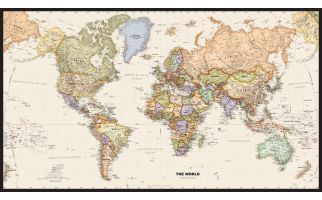 Legacy World Wall MapPerfect for home, business, or school, this Legacy World Wall Map combines bright, attractive colors with high-detailed cartography in an antique style. Details on this World Wall Map include: international boundaries and national capitals along with other major cities; major physical features such as mountain ranges, major mountain peaks, island chains, and deserts; and major water features such as oceans, seas, gulfs, and rivers. Special features include ivory-colored oceans and a black decorative border. This map of the world uses the Van Der Grinten projection. The 2020 edition features several city-name changes in Alaska, Angola, South Africa, and Turkmenistan Learn MorePrice from $39.99
 -
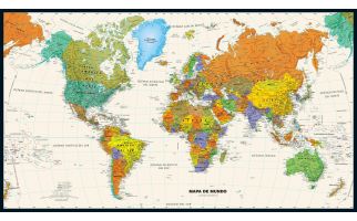 Contemporary World Wall Map in SpanishPerfect for home, business, or school, this Contemporary World Wall Map in Spanish combines bright, attractive colors with high-detailed cartography. Details on this World Wall Map include: international boundaries and national capitals along with other major cities; major physical features such as mountain ranges, major mountain peaks, island chains, and deserts; and major water features such as oceans, seas, gulfs, and rivers. Special features include ivory-colored oceans and a black decorative border. This map of the world uses the Van Der Grinten projection. The 2020 edition features several city-name changes in Alaska, Angola, South Africa, and Turkmenistan. Perfecto para el hogar, negocio o escuela, este Mapa del Mundo Contemporáneo Muro en Español combina, atractivos colores brillantes con alta detallada cartografia. Los detalles sobre este mundo Mapa mural incluyen: las fronteras internacionales y de capitales nacionales, junto con otras grandes ciudades; principales características físicas, tales como cadenas montañosas, los principales picos de las montañas, cadenas de islas y desiertos; y las principales características del agua como océanos, mares, golfos, y ríos. Las características especiales incluyen océanos de color marfil y una frontera decorativa negro. Este mapa del mundo utiliza la proyección Van Der Grinten. La edición 2020 presenta varios cambios en el nombre de la ciudad en Alaska, Angola, Sudáfrica y Turkmenistán. Learn MorePrice from $34.99
 -
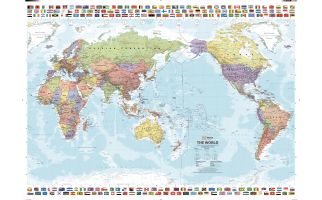 Pacific Centred World & Flags
A world political map that is bordered by the flags of the world.
Learn MorePrice from $45.99 -
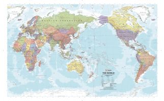 Pacific Centred World Political Supermap
A world political map that features relief shading to accurately depict each country's topography, which combined with an index makes the World Supermap the perfect educational tool, reference point or decorative map.
Learn MorePrice from $72.50 -
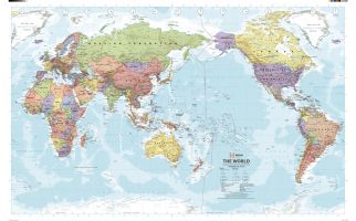 Pacific Centred World Political Wall Map
A world political map that features relief shading to accurately depict each country's topography, which combined with an index makes the World Supermap the perfect educational tool, reference point or decorative map.
Learn MorePrice from $45.50 -
 Contemporary World Wall Map
Perfect for home, business, or school, this Contemporary World Wall Map combines bright, attractive colors with high-detailed cartography. Details on this World Wall Map include: international boundaries and national capitals along with other major cities; major physical features such as mountain ranges, major mountain peaks, island chains, and deserts; and major water features such as oceans, seas, gulfs, and rivers.
Special features include ivory-colored oceans and a black decorative border. This map of the world uses the Van Der Grinten projection.
Learn MorePrice from $39.99 -
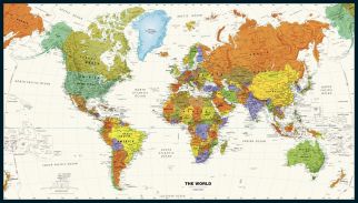
 Political World Wall Map
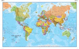
One of the best selling world maps that can be an educational resource as well as a stylish feature on your wall. Politically coloured world wall map features every country as a different colour. All major towns and cities are featured on this map and capital cities are clearly marked. Hill and sea shading add to the vibrant overall effect in this political world wall map.
Learn MorePrice from $59.99 -
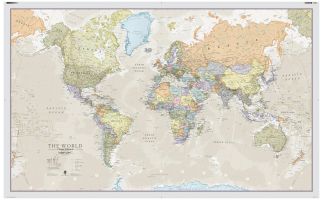 Classic World Map
A popular classic world map with its artistic classic-style muted tones; it looks simply stunning and rather elegant. Splendid wall map art of the world in vintage style. Complete with political detail (countries shaded in different tones), country boundaries and cities shown.
Learn MorePrice from $59.99 -
 The World Wall Map - Atlas of Canada
This map shows the World at an equatorial scale of 1: 35 000 000. The map is a general reference sheet focusing on showing the name and status of all sovereign countries and dependencies, and showing major cities. The 2005 version has two new additions: one is showing shaded relief for land areas, the other is showing bathymetric contours and colours for all marine areas.
Learn MorePrice from $39.99 -
 Le monde - Carte Murale - L'Atlas du Canada
La série de cartes de référence de 1961 à 2010 de l'Atlas du Canada contient la plus récente version d'une carte mise à jour régulièrement et provenant de la série de cartes de base de l'Atlas national du Canada. Chaque version présente le monde à une échelle équatoriale de 1/35 000 000. Cette carte de référence générale indique le nom et le statut de tous les pays souverains et dépendants, ainsi que les grandes villes. La version de 2005 comporte deux nouveaux ajouts : le relief des terres émergées est représenté par ombres portées, et toutes les étendues marines sont illustrées par des isobathes et des teintes bathymétriques.
Learn MorePrice from $37.99