World Maps by Years
Unleash important events, activities, major discoveries, achievements, and other milestones through these world timeline maps. The maps include stories from ancient times, relevant historical sites, regions, and religions. They are ideal wall decor for people who want to stay close to their origin. The maps are printed and published by the world's renowned publishers like National Geographic.
-
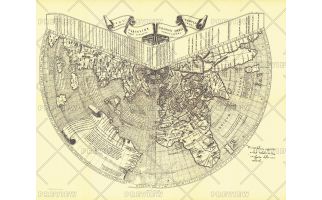 Ruysch 1508 Map - Published 1893
One of the first maps of the new world, Johannes Ruysch made this map, using a polar projection, which includes an extensive view of South America, islands of the West Indies, and a portion of North America. The World Map from Ruysch appeared for the first time among the Tabulae Novae in some copies of the 1507 Rome edition of Ptolemy's Geography. Ruysch's map illustrates a number of significant geographic features more correctly than before, especially along the easterly sea route to the Orient which was of prime importance to early sixteenth-century Europeans. An incredible historical piece.
Learn MorePrice from $27.99 -
 Chronicon Nurembergense 1493 Map - Published 1893
Originally produced only in woodcut form, the Chronicon Nurembergense Map of 1493 was published in National Geographic Magazine in April 1893, just five years after the Society's inception. This Latin version was first published in April of 1493, followed by a German version in December of the same year. A perfect companion to the world map by Johannes Ruysch.
Learn MorePrice from $27.99 -
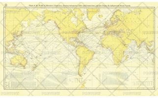 Chart of the World on Mercator's Projection - Published 1905
Submarine cables have played an important part in the development of world-wide communications since the 1850's. National Geographic first charted these cables in 1896. In comparison to that earlier map, this map, published in February 1905 reveals the explosion of communications infrastructure worldwide at the beginning of the last century.
Learn MorePrice from $49.99 -
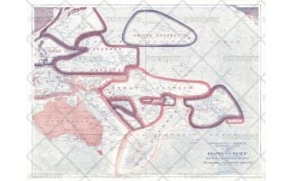 Sovereignty and Mandate Boundary Lines of the Islands of the Pacific - Published 1921
A truly unique work, this map of the Pacific Islands illustrates the sovereignty and mandate boundaries of the islands. This map was published in December 1921 in an issue of National Geographic that was entirely devoted to the islands of the Pacific. A compelling piece for collectors and those interested in the history of the region.
Learn MorePrice from $30.99 -
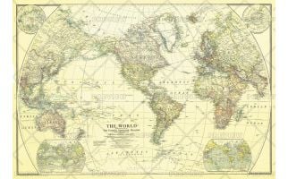 World - Published 1922
This classic world map, published in December of 1922, shows the world's political boundaries established following WWI. This map also shows airplane routes that had been established, as well as railroad routes.
Learn MorePrice from $45.99 -
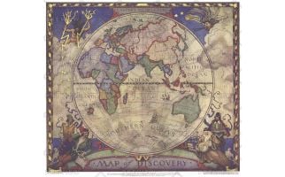 Map of Discovery, Eastern Hemisphere - Published 1928
This historic map of the Eastern Hemisphere simulates the illuminated mariners' charts of the 17th Century. The original murals, painted by N.C. Wyeth, are in Hubbard Hall at the National Geographic Society headquarters.
Learn MorePrice from $27.99 -
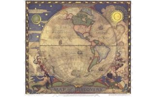 Map of Discovery, Western Hemisphere - Published 1928
In 1927, famed American painter N. C. Wyeth completed a series of five murals for Hubbard Memorial Hall, the National Geographic Society's first formal library. The Map of Discovery: Western Hemisphere, published in January 1929, is one of those outstanding murals. It features Poseidon and a mermaid keeping watch over the oceans as well as the routes of explorers and dates of expeditions.
Learn MorePrice from $27.99 -
 World - Published 1932
Vintage National Geographic colors and spectacular detail accentuate this beautiful world map, first published in National Geographic Magazine in December of 1932, accompanying an article entitled, "The Story of the Map."
Learn MorePrice from $39.99 -
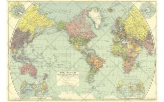
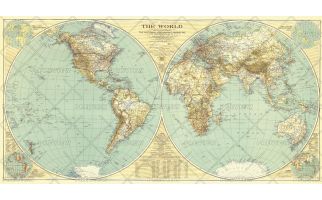 World - Published 1935
A National Geographic classic, this world map is as much a work of art as it is an incomparable reference for its time. In this map, the world's eastern and western hemispheres are show separately to give the viewer a true sense of area across the continents.
Learn MorePrice from $39.99 -
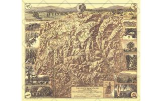 White Mountains of New Hampshire - Published 1937
Appearing in National Geographic Magazine in July 1937, the White Mountains of New Hampshire map highlights the scenic points of interest and outdoor activities to be enjoyed in this lovely region. The map's mountain relief and border of sketches make it a perfect wall-hanging.
Learn MorePrice from $27.99 -
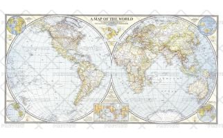 World Map - Published 1941
The Classic National Geographic World map of 1941. One of the last maps published prior to the bombing of Pearl Harbor, this extaordinary map shows the Eastern and Western Hemispheres, and features classic colorization to show the country borders and relief shading. A perfect complement to any world map collection.
Learn MorePrice from $39.99 -
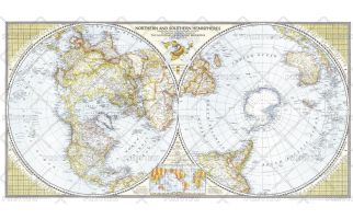 Northern and Southern Hemispheres - Published 1943
A true classic, this world map first published in April of 1943, shows the northern and southern hemisphers side by side, to give the viewer a perspective that centers each hemisphere on its pole. New to this map were special insets showing airline distances in the Eastern, Western, Northern, and Southern Hemispheres. Stunning cartography and special details make this a marvelous collector's item.
Learn MorePrice from $39.99