Port Alberni British Columbia Map
Port Alberni, British Columbia map can be ordered in high-quality print of your selection in the orientation, size & paper, laminated or matt plastic finish of your choice. The map is available the scale of 1:12,000 in 24 x 36 inches and portrait orientation.You can also customize the map here to center around the area of your interest such as a business location, sales territory in a different scale, size and orientation.
We also offer a premium version of this Port Alberni, British Columbia Map using TomTom's map data starting at $39.99. If you have any questions, we will be happy to answer over the phone (866) 525-2298 or write to us
We also offer a premium version of this Port Alberni, British Columbia Map using TomTom's map data starting at $39.99. If you have any questions, we will be happy to answer over the phone (866) 525-2298 or write to us
This map is available in 24 x 36 in. Please select a finish of your choice
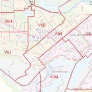
Port Alberni BC Map
The Port Alberni BC map shows the highway infrastructure including, interchanges, weigh stations and tolls. You can locate major infrastructures like airports, hospitals, shopping malls, exhibition centers, industrial complexes, and other business-centric features on the map. Full street labeling, block numbers, and street directions make this map ideal for the business owner who needs local or regional road network information for service delivery, catchment area or sales territory.
This Port Alberni map can also be customized around your preferred location by clicking on 'Close Preview'. You can add a title, choose a size, orientation and finishing material of your choice before placing an order.
About Port Alberni BC
The city of Port Alberni on Vancouver Island in British Columbia is a deep port city which lies within the Alberni Valley at the head of the Alberni Inlet, Vancouver Island's longest inlet.
It sits beneath Mount Arrowsmith and is completely surrounded by mountains. Because of these mountains, Port Alberni is known for some of the best hiking places on Vancouver Island. You can also view the wildlife, including deer and black bears.
A major source of employment in the city is the forest industry that consists of Douglas fir, hemlock, yellow cedar, and western red cedar. Other than that, Port Alberni Mill that produces 340,000 tonnes of directory paper and lightweight coated paper each year is also a source of employment. Several lumber mill and sawmills also exist throughout the valley.
| SKU | svd_bc_port_alberni |
|---|---|
| Flat Size | 24 x 36 in |
| Publisher Name | MapSherpa |
Write Your Own Review
Similar Products