National Parks
Find National Parks maps of the US, UK, Canada, and many other countries. These maps highlight magnificent national parks and trails with separate inset maps providing detailed descriptions of relief, landscapes, river systems with updated trail and road information. Rich topographic details and splendid scenery makes these maps a must have while traveling and exploring.
-
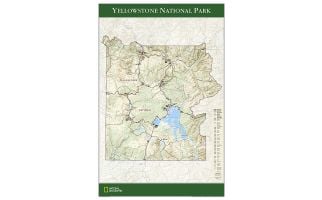 Yellowstone National Park Map
Wall map of Yellowstone National Park, based on the popular Trails Illustrated map of the park, provides rich topographic detail to show the Wyoming park's magnificent mountains and valleys, as well as updated trail, road and facilities information.
Learn MorePrice from $34.99 -
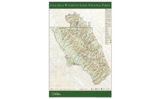 Glacier and Waterton Lakes National Parks Map
The wall map of Glacier and Waterton Lakes National Parks, based on the popular Trails Illustrated map of the area, provides rich topographic detail to show the Montana and Alberta parks' magnificent scenery, as well as updated trail and road information for the "Crown of the Continent."
Learn MorePrice from $34.99 -
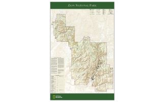 Zion National Park Map
The wall map of Zion National Park, based on the popular Trails Illustrated map of the park, provides rich topographic detail to show the Utah park's magnificent scenery, as well as updated trail and road information.
Learn MorePrice from $34.99 -
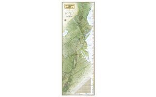 Appalachian Trail Wall Map
National Geographic's wall map of the Appalachian Trail is ideal for fans and hikers of this magnificent national scenic trail.
Learn More
Developed in cooperation with the Appalachian Trail Conservancy, this beautiful poster, measuring 48"x18", shows the entire length of the trail from Maine to Georgia. A unique elevation profiles highlight the trail's peaks and valleys and an informative mileage chart shows the distance between key locations. Also highlighted on the map are National Forests, National Park Service lands, State Forests and Parks, and major highways and interstates. Points of interest include Appalachian Trail information centers and shelters.
Net proceeds from the sale of this map support National Geographic's vital exploration, conservation, research, and education programs.Price from $34.99