World Maps by Years
Unleash important events, activities, major discoveries, achievements, and other milestones through these world timeline maps. The maps include stories from ancient times, relevant historical sites, regions, and religions. They are ideal wall decor for people who want to stay close to their origin. The maps are printed and published by the world's renowned publishers like National Geographic.
-
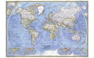
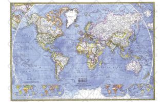 Political World - Published 1975
This beautiful world map emphasizes international political boundaries, and is peppered with thousands of place names across the globe. Published in November of 1975.
Learn MorePrice from $32.99 -
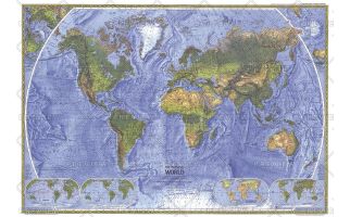 Physical World - Published 1975
The splendor and beauty of the world's natural features come to life in this physical world map. Mountain ranges, major rivers, vegetation zones, and deserts are depicted, and major physical features are named to provide easy reference. Published in November 1975.
Learn MorePrice from $32.99 -
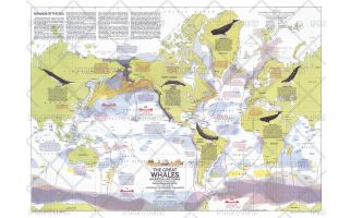 Great Whales, Migration and Range - Published 1976
This map illustrates the migration and range of the six species of great whales, including the Fin, Humpback, Sperm, Gray, Bowhead, and Right. Provides information about how commercial whaling has decimated the populations of these magnificent mammals, and the actions being taken to protect them. Published in December 1976 with two articles on whales and the "Whales of the World" poster.
Learn MorePrice from $33.99 -
 Whales of the World - Published 1976
The Whales of the World poster was printed in December 1976 as a supplement to the Great Whales map. Featuring an overview article about whales, information about each species, and beautiful paintings by Larry Foster, this work is a must-have for anyone enamored of these magnificent giants of the sea.
Learn MorePrice from $33.99 -
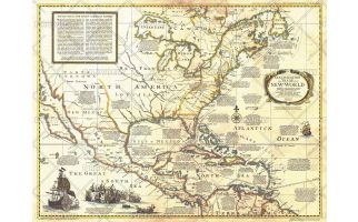 Colonization and Trade in New World - Published 1977
The "Colonization and Trade in the New World" historical map provides information on exploration, trade, and colonization in the New World combined with an antique-style cartography. Printed in December 1977, this map and its companion poster, "History Salvaged from the Sea" make up the two-piece set that accompanied the articles "Reach for the New World" and "Who Discovered America? A New Look at an Old Question."
Learn MorePrice from $33.99 -
 World - Published 1981
This classic World Map beautifully showcases cartograhic excellence and fine attention to detail, using strong colors, detailed geographical information, and informative insets. Published in December 1981.
Learn MorePrice from $39.99 -
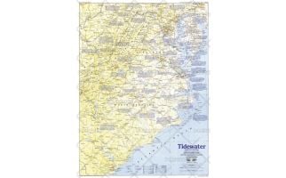 Tidewater and Environs - Published 1988
This map of the United States region of the Carolinas, Virginia, and neighboring states contains an abundance of historical sites and notes. Published in June 1988 as half of a two–map set in the "Making of America" series.
Learn MorePrice from $31.99 -
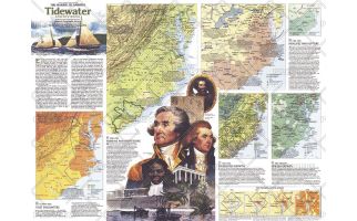 Tidewater and Environs Theme - Published 1988
An area teeming with activity since the English settlement of Jamestown, the Tidewater region includes the Carolinas, Virginia, Maryland, Delaware, and the District of Columbia. The Tidewater and Environs map, published in June 1988, provides a wealth of historical information about this vital maritime region. Part of the "Making of America" series, this map represents Side Two in a two-piece set.
Learn MorePrice from $31.99 -
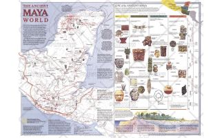 Ancient Maya World - Published 1989
Explore the fascinating world of the Maya with this map published in October 1989. This map accompanied the "Land of the Maya" map in the same issue and three articles on the Maya including "La Ruta Maya." This work features an abundance of information about trade, travel, and the landscape of their civilization, including an explanation of the various eras of Maya history.
Learn MorePrice from $31.99 -
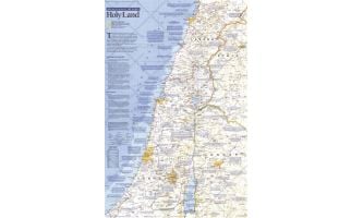 Special Places of the World, Holy Land - Published 1989
This map of the Holy Land features beautiful cartography combined with copious historic, religious, and geographic facts about this land of faith and conflict. Printed in December 1989 as part of the "Special Places of the World" series.
Learn MorePrice from $33.99 -
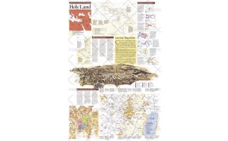 Special Places of the World, Holy Land Theme - Published 1989
Half of a two-page layout on the Holy Land, this educational supplement teems with details of the history of the land held sacred by Jews, Christians, and Muslims. An extraordinary illustration of Jerusalem notes important sites and the Crossroads of Empires inset reveals the history of the region's occupation. Printed in December 1989, this work stands alone or perfectly compliments the map of the Holy Land that appeared in the same issue.
Learn MorePrice from $33.99 -
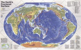 The Earths Fractured Surface - Published 1995
Like the pieces of a jigsaw puzzle, slabs of rocky crust known as tectonic plates fit together to form the outer shell of the Earth. This world map shows the contintents, along with the lines of each tectonic plate, demonstrating the reaction between continental drift, earthquakes and volcanoes.
Learn MorePrice from $32.99