World Maps by Years
Unleash important events, activities, major discoveries, achievements, and other milestones through these world timeline maps. The maps include stories from ancient times, relevant historical sites, regions, and religions. They are ideal wall decor for people who want to stay close to their origin. The maps are printed and published by the world's renowned publishers like National Geographic.
-
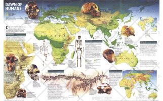 Dawn of Humans - Published 1997
This fascinating map contains a wealth of information on our quest to discover the history of our prehistoric ancestors including fossil sites, information on significant hominid finds, and the challenges researchers face. Published in February 1997 with the "Seeking Our Origins" companion map, this work also includes maps which show the vegetation zones 125,000 years ago, 65,000 years ago, and today.
Learn MorePrice from $33.99 -
 Seeking Our Origins - Published 1997
Published in February 1997 with the Dawn of Humans map and article, this compelling work contains illustrations of the various hominid species discovered. A timeline and other information puts the dawn of early man into perspective.
Learn MorePrice from $33.99 -
 Bird Migration Eastern Hemisphere - Published 2004
This map illustrates the incredible journeys that birds undertake in the Americas each year. The migration paths of sixty seven types of birds are shown on a map of the Americas that is overlaid with pathways that their routes, from nesting grounds to wintering areas. Full-color bird paintings by noted illustrator Arthur Singer show each of the sixty seven species.
Learn MorePrice from $33.99 -
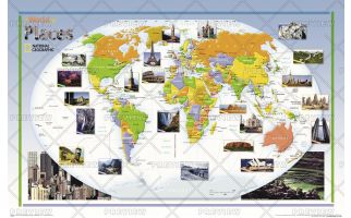 World of Places - Published 2004
This colorful, educational map for kids features large photographs of notable landmarks and places throughout the world.
Learn MorePrice from $35.99 -
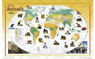 World of Animals - Published 2004
This colorful, educational map for kids features large photographs of animals throughout the world and indicates the areas where they live. The map shows the earth's vegetation zones in beautiful detail.
Learn MorePrice from $35.99 -
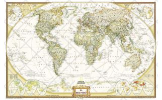 World Executive Spanish - Published 2005
National Geographic's Executive style World Map translated to Spanish features the Winkel Tripel projection to reduce distortion of land masses as they near the poles. This creates the most visually accurate representation of Earth's land-masses, versus other projections. The Classic series includes blue oceans, easy-to-read colorful boundaries, and National Geographic's proprietary fonts. Up-to-date and very detailed, with thousands of named places such as countries, oceans, major cities, geographic features. Antique executive styling. Prevailing winds and ocean currents at sea. Separate insets show the North and South Polar Regions, world vegetation and land use, and world population density.
Learn MorePrice from $39.99 -
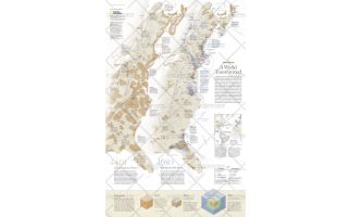 A World Transformed - Published 2007
This revealing pair of maps show the dramatic differences in Native-American and European populations along the eastern coast of North America in 1491 and 1650. Population graphics reveal changes in population from 1500 to 1800. Published in May 2007, this map represents half of a two-map set. Its companion map, "1607: When Cultures Collide," is also available.
Learn MorePrice from $33.99 -
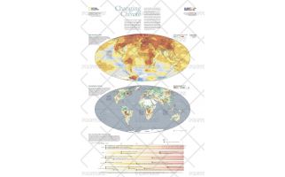 Changing Climate - Published 2007
The scientific evidence is clear: Surface temperatures on Earth are warming at a pace that signals a decisive shift in the global climate, one expected to last for centuries. Climate is changing more rapidly than ever before and human activity is the main cause. Burning of fossil fuels has flooded the atmosphere with heat-trapping carbon dioxide, triggering a 1 degree (F) spike in average global temperature in the past century, largely in the past 30 years. This informative map, published in October 2007 as half of a two-map set with "Greenhouse Earth," reveals evidence which suggests that unless CO2 emissions are slashed, the planet will likely heat up even faster, fundamentally changing the world we live in.
Learn MorePrice from $33.99 -
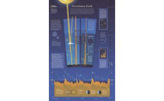 Greenhouse Earth - Published 2007
Published in October 2007 as half of a two-piece set with "Changing Climate," this revealing poster explains how the Earth's atmosphere acts as a greenhouse and how carbon emissions raise the planet's surface temperature. Graphs and charts reveal the origin of emissions, predicted future carbon emission levels, and the warming cycles the planet has experienced in its history.
Learn MorePrice from $33.99 -
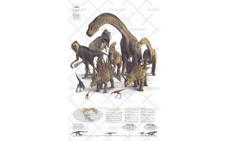
 Planet of the Dinosaurs Gondwana - Published 2007
More than 550 species of dinosaurs have been named, and scientists estimate that more than a thousand others are waiting to be found. When the supercontient Pangaea separated into two great landmasses, Gondwana in the south and Laurasia in the north, dinosaur populations were divided into two main populations that evolved mostly in isolation from each other until they met their end 65 million years ago. This remarkable poster was published in December 2007 as half of a two-piece set. It features ten of the dinosaurs that roamed Gondwana in the southern hemisphere.
Learn MorePrice from $33.99 -
 Planet of the Dinosaurs Laurasia - Published 2007
When the supercontient Pangaea separated into two great landmasses, Gondwana in the south and Laurasia in the north, dinosaur populations were divided into two main populations that evolved mostly in isolation from each other until they met their end 65 million years ago. This remarkable poster was published in December 2007 as half of a two-piece set. It features ten of the dinosaurs that roamed Laurasia in the northern hemisphere. More than 550 species of dinosaurs have been named, and scientists estimate that more than a thousand others are waiting to be found.
Learn MorePrice from $33.99 -
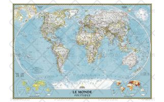 World Map in French
A National Geographic World Map (Carte du Monde en Français) shows crucial geographic details, political boundaries and comes with close up insets and an easy reference index.
Learn MorePrice from $39.99