World Maps by Years
Unleash important events, activities, major discoveries, achievements, and other milestones through these world timeline maps. The maps include stories from ancient times, relevant historical sites, regions, and religions. They are ideal wall decor for people who want to stay close to their origin. The maps are printed and published by the world's renowned publishers like National Geographic.
-
 Teammates in Mankinds Greatest Adventure - Published 1973
Space enthusiasts will appreciate this Pierre Mion poster depicting all of the Apollo astronauts in their space suits and equipment on a lunar landscape. Accurate in every detail.
Learn MorePrice from $32.99 -
 Political World - Published 1975
This beautiful world map emphasizes international political boundaries, and is peppered with thousands of place names across the globe. Published in November of 1975.
Learn MorePrice from $32.99 -
 Physical World - Published 1975
The splendor and beauty of the world's natural features come to life in this physical world map. Mountain ranges, major rivers, vegetation zones, and deserts are depicted, and major physical features are named to provide easy reference. Published in November 1975.
Learn MorePrice from $32.99 -
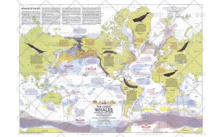 Great Whales, Migration and Range - Published 1976
This map illustrates the migration and range of the six species of great whales, including the Fin, Humpback, Sperm, Gray, Bowhead, and Right. Provides information about how commercial whaling has decimated the populations of these magnificent mammals, and the actions being taken to protect them. Published in December 1976 with two articles on whales and the "Whales of the World" poster.
Learn MorePrice from $33.99 -
 Whales of the World - Published 1976
The Whales of the World poster was printed in December 1976 as a supplement to the Great Whales map. Featuring an overview article about whales, information about each species, and beautiful paintings by Larry Foster, this work is a must-have for anyone enamored of these magnificent giants of the sea.
Learn MorePrice from $33.99 -
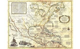 Colonization and Trade in New World - Published 1977
The "Colonization and Trade in the New World" historical map provides information on exploration, trade, and colonization in the New World combined with an antique-style cartography. Printed in December 1977, this map and its companion poster, "History Salvaged from the Sea" make up the two-piece set that accompanied the articles "Reach for the New World" and "Who Discovered America? A New Look at an Old Question."
Learn MorePrice from $33.99 -
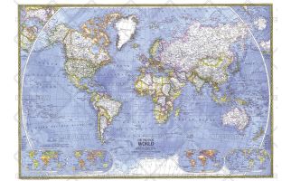
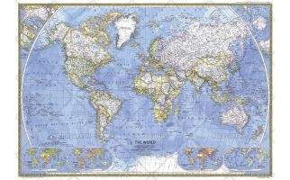 World - Published 1981
This classic World Map beautifully showcases cartograhic excellence and fine attention to detail, using strong colors, detailed geographical information, and informative insets. Published in December 1981.
Learn MorePrice from $39.99 -
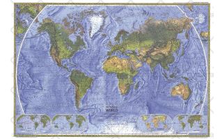
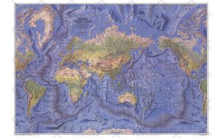 World Ocean Floor - Published 1981
This beautiful physical world map captures the Earth's lands and oceans. Stunning relief shading accentuates the ocean floor, mountain ranges, river valleys, deserts, and continental shelves in amazing detail and beauty. Published in December 1981.
Learn MorePrice from $45.99 -
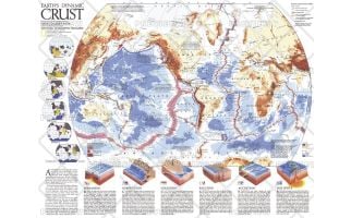 Earths Dynamic Crust - Published 1985
Explore the forces behind the shaping of our planet. This fascinating map explains the various forms of tectonic activity such as hot spots, accretion, subduction, and spreading. It also shows the locations of volcanoes and earthquakes of 6.0 magnitude or greater that occurred during 1975-1985. Published in August 1985 as half of a two–map set with "The Shaping of a Continent: North America's Active West", and as a companion to the article "Our Restless Planet Earth."
Learn MorePrice from $24.99 -
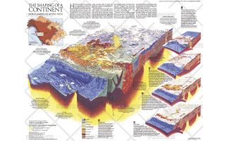 The Shaping of a Continent - Published 1985
Half of a two-map set, the "Shaping of a Continent: North America's Active West" map features detail of the one of the most active tectonic areas in the world. Published in August 1985, this map accompanied the "Earth's Dynamic Crust" map and the article "Our Restless Planet Earth."
Learn MorePrice from $27.99 -
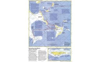 Threading the Islands - Published 1986
The "Threading the Islands" map explores two possible routes of Columbus's journey and possible landing sites. The Morisson track asserts that the explorer landed on San Salvador, while the Judge track favors Samana Cay. This map was printed in November 1986 to accompany three articles on Columbus and the "Where Did Columbus Discover America?" map. A fascinating new look at a centuries-old question.
Learn MorePrice from $27.99 -
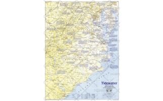 Tidewater and Environs - Published 1988
This map of the United States region of the Carolinas, Virginia, and neighboring states contains an abundance of historical sites and notes. Published in June 1988 as half of a two–map set in the "Making of America" series.
Learn MorePrice from $31.99