World Maps by Years
Unleash important events, activities, major discoveries, achievements, and other milestones through these world timeline maps. The maps include stories from ancient times, relevant historical sites, regions, and religions. They are ideal wall decor for people who want to stay close to their origin. The maps are printed and published by the world's renowned publishers like National Geographic.
-
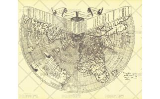 Ruysch 1508 Map - Published 1893
One of the first maps of the new world, Johannes Ruysch made this map, using a polar projection, which includes an extensive view of South America, islands of the West Indies, and a portion of North America. The World Map from Ruysch appeared for the first time among the Tabulae Novae in some copies of the 1507 Rome edition of Ptolemy's Geography. Ruysch's map illustrates a number of significant geographic features more correctly than before, especially along the easterly sea route to the Orient which was of prime importance to early sixteenth-century Europeans. An incredible historical piece.
Learn MorePrice from $27.99 -
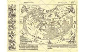 Chronicon Nurembergense 1493 Map - Published 1893
Originally produced only in woodcut form, the Chronicon Nurembergense Map of 1493 was published in National Geographic Magazine in April 1893, just five years after the Society's inception. This Latin version was first published in April of 1493, followed by a German version in December of the same year. A perfect companion to the world map by Johannes Ruysch.
Learn MorePrice from $27.99 -
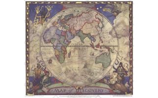 Map of Discovery, Eastern Hemisphere - Published 1928
This historic map of the Eastern Hemisphere simulates the illuminated mariners' charts of the 17th Century. The original murals, painted by N.C. Wyeth, are in Hubbard Hall at the National Geographic Society headquarters.
Learn MorePrice from $27.99 -
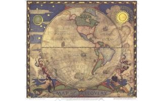 Map of Discovery, Western Hemisphere - Published 1928
In 1927, famed American painter N. C. Wyeth completed a series of five murals for Hubbard Memorial Hall, the National Geographic Society's first formal library. The Map of Discovery: Western Hemisphere, published in January 1929, is one of those outstanding murals. It features Poseidon and a mermaid keeping watch over the oceans as well as the routes of explorers and dates of expeditions.
Learn MorePrice from $27.99 -
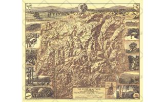 White Mountains of New Hampshire - Published 1937
Appearing in National Geographic Magazine in July 1937, the White Mountains of New Hampshire map highlights the scenic points of interest and outdoor activities to be enjoyed in this lovely region. The map's mountain relief and border of sketches make it a perfect wall-hanging.
Learn MorePrice from $27.99 -
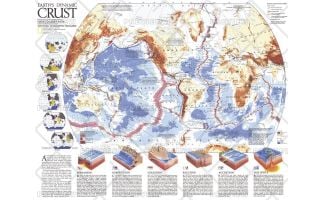 Earths Dynamic Crust - Published 1985
Explore the forces behind the shaping of our planet. This fascinating map explains the various forms of tectonic activity such as hot spots, accretion, subduction, and spreading. It also shows the locations of volcanoes and earthquakes of 6.0 magnitude or greater that occurred during 1975-1985. Published in August 1985 as half of a two–map set with "The Shaping of a Continent: North America's Active West", and as a companion to the article "Our Restless Planet Earth."
Learn MorePrice from $24.99 -
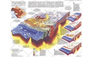 The Shaping of a Continent - Published 1985
Half of a two-map set, the "Shaping of a Continent: North America's Active West" map features detail of the one of the most active tectonic areas in the world. Published in August 1985, this map accompanied the "Earth's Dynamic Crust" map and the article "Our Restless Planet Earth."
Learn MorePrice from $27.99 -
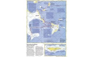 Threading the Islands - Published 1986
The "Threading the Islands" map explores two possible routes of Columbus's journey and possible landing sites. The Morisson track asserts that the explorer landed on San Salvador, while the Judge track favors Samana Cay. This map was printed in November 1986 to accompany three articles on Columbus and the "Where Did Columbus Discover America?" map. A fascinating new look at a centuries-old question.
Learn MorePrice from $27.99 -
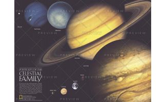 Portraits of Our Celestial Family - Published 1990
A beautiful companion to the Solar System map that appeared in the same issue, this compelling work illustrates the varied faces of the planets in our solar system. Published in August 1990 with two articles, "Neptune: Voyager's Last Picture Show" and "Voyage of the Century," this work shows the planets scaled to relative size, their portraits made from actual images taken from various spacecraft.
Learn MorePrice from $27.99 -
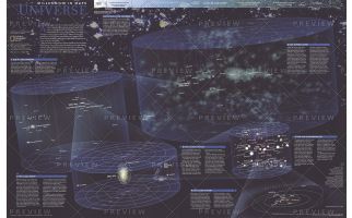 The Universe - Published 1999
Published in October 1999, this fascinating poster contains five maps of our solar system and beyond including: the solar system, our sun's neighborhood, our galactic realm, our local group, and our supercluster. Half of a two-map set in the "Millennium In Maps" series, its companion map entitled "The Milky Way" is also available. Together, the two maps present a striking portrait of the universe as we know it and a hint at what might lie beyond.
Learn MorePrice from $29.99 -
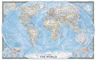 World - Published 2004
Published in November 2004, this political map of the world will look handsome framed and mounted on any wall. Inset maps of the polar regions as well as language families and population density make this map as informative as it is attractive. This map was originally printed as half of a two-map set with "Earth at Night."
Learn MorePrice from $29.99 -
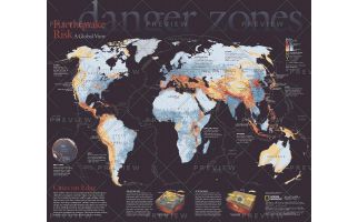 Danger Zones, Earthquake Risk, a Global View - Published 2006
Never before have so many people packed into earthquake-prone cities like Los Angeles, Istanbul, Tokyo, and Lima. Located near the boundaries between Earth's huge, shifting crustal plates, these cities face a rising risk of death and economic disaster from large earthquakes. This eye-catching map reveals the areas most at risk and their populations. Published in April 2006, this map was half of a two-piece set with
Learn MorePrice from $27.99