Top World Maps
Find every bestselling world map from eminent map publishers in one place! Ranging from legacy maps, Pacific centered maps, to the graphic world map, this collection has it all. These maps are a great source for both geographic and political information. Available in various styles like antique, classic, and contemporary they are perfect for home, business, and educational references.
-
 Artistic World Wall Map
World political mapping and vibrant colours combine to make this beautiful, colourful map with a difference.
Learn MorePrice from $34.99 -
 Colour blind friendly Political Wall Map of the World
There is likely to be at least one child in every classroom that is colour blind. Designed especially to work with any form of colour blindness, this colourful, easy to read children's map of the World showing the countries and their capitals is ideal for the classroom.
Learn MorePrice from $39.99 -
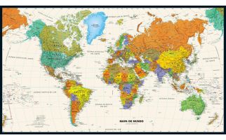
 Political World Wall Map, Spanish Language
Political World Wall Map in Spanish. Mapa político del muro mundial en español.
Learn MorePrice from $34.99 -
 Political World Wall Map, Portuguese Language
Political World Wall Map in Portuguese. Mapa do Muro Mundial Político em Português.
Learn MorePrice from $34.99 -
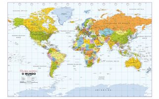
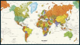
 Legacy World Wall MapPerfect for home, business, or school, this Legacy World Wall Map combines bright, attractive colors with high-detailed cartography in an antique style. Details on this World Wall Map include: international boundaries and national capitals along with other major cities; major physical features such as mountain ranges, major mountain peaks, island chains, and deserts; and major water features such as oceans, seas, gulfs, and rivers. Special features include ivory-colored oceans and a black decorative border. This map of the world uses the Van Der Grinten projection. The 2020 edition features several city-name changes in Alaska, Angola, South Africa, and Turkmenistan Learn MorePrice from $39.99
 -
 Contemporary World Wall Map in SpanishPerfect for home, business, or school, this Contemporary World Wall Map in Spanish combines bright, attractive colors with high-detailed cartography. Details on this World Wall Map include: international boundaries and national capitals along with other major cities; major physical features such as mountain ranges, major mountain peaks, island chains, and deserts; and major water features such as oceans, seas, gulfs, and rivers. Special features include ivory-colored oceans and a black decorative border. This map of the world uses the Van Der Grinten projection. The 2020 edition features several city-name changes in Alaska, Angola, South Africa, and Turkmenistan. Perfecto para el hogar, negocio o escuela, este Mapa del Mundo Contemporáneo Muro en Español combina, atractivos colores brillantes con alta detallada cartografia. Los detalles sobre este mundo Mapa mural incluyen: las fronteras internacionales y de capitales nacionales, junto con otras grandes ciudades; principales características físicas, tales como cadenas montañosas, los principales picos de las montañas, cadenas de islas y desiertos; y las principales características del agua como océanos, mares, golfos, y ríos. Las características especiales incluyen océanos de color marfil y una frontera decorativa negro. Este mapa del mundo utiliza la proyección Van Der Grinten. La edición 2020 presenta varios cambios en el nombre de la ciudad en Alaska, Angola, Sudáfrica y Turkmenistán. Learn MorePrice from $34.99
 -
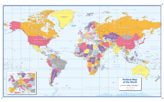
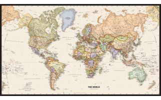
 Contemporary World Wall Map
Perfect for home, business, or school, this Contemporary World Wall Map combines bright, attractive colors with high-detailed cartography. Details on this World Wall Map include: international boundaries and national capitals along with other major cities; major physical features such as mountain ranges, major mountain peaks, island chains, and deserts; and major water features such as oceans, seas, gulfs, and rivers.
Special features include ivory-colored oceans and a black decorative border. This map of the world uses the Van Der Grinten projection.
Learn MorePrice from $39.99 -
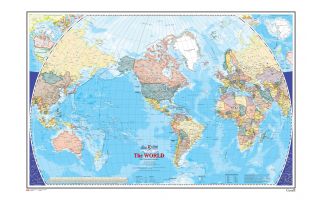 The World Wall Map - Atlas of Canada
This map shows the World at an equatorial scale of 1: 35 000 000. The map is a general reference sheet focusing on showing the name and status of all sovereign countries and dependencies, and showing major cities. The 2005 version has two new additions: one is showing shaded relief for land areas, the other is showing bathymetric contours and colours for all marine areas.
Learn MorePrice from $39.99 -
 Le monde - Carte Murale - L'Atlas du Canada
La série de cartes de référence de 1961 à 2010 de l'Atlas du Canada contient la plus récente version d'une carte mise à jour régulièrement et provenant de la série de cartes de base de l'Atlas national du Canada. Chaque version présente le monde à une échelle équatoriale de 1/35 000 000. Cette carte de référence générale indique le nom et le statut de tous les pays souverains et dépendants, ainsi que les grandes villes. La version de 2005 comporte deux nouveaux ajouts : le relief des terres émergées est représenté par ombres portées, et toutes les étendues marines sont illustrées par des isobathes et des teintes bathymétriques.
Learn MorePrice from $37.99 -
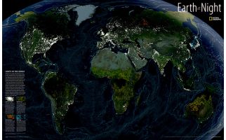 Earth at Night
This intriguing map reveals in stunning detail the pulsating lights of the Earth at night. See where populations are most and least concentrated. The rare view is a composite image made by three satellites on cloud-free nights over a one-year period. In addition to showing lighted areas of the Earth, this map also features where fires rage and natural gas burn-off and night fishing locations.
Learn MorePrice from $34.99 -
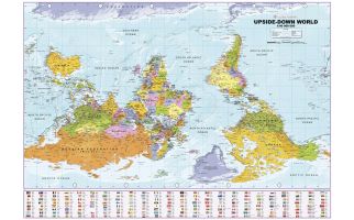 Upside Down World Political Wall Map
The unique Upside-down World map gives the world a twist. Many refer to it as the south-up map poster as it shows the south at the top and amounts to a 180-degree rotation - unlike the standard convention of the north-up. The map highlights the political features like countries, capitals, cities in legible texts with an additional panel at the bottom that shows country flag symbols for identification.
Learn MorePrice from $32.99