Ottawa - Gatineau Postal Code Forward Sortation Areas Map
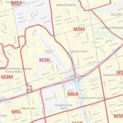
This map of Ottawa-Gatineau shows postal code forward sortation areas overlaid on a road map. Ideal for planning of deliveries, home services, sales territories, real estate and much more. Base map features include all roads with major roads and highways labelled; neighbourhood names; railways; and high level land use such as parks and recreation areas, industrial areas and hospital campuses.
This map is available in 48 x 36 in. Please select a finish of your choice
Gatineau Ottawa Postal Code Map
This map of Ottawa and Gatineau shows postal code forward sortation areas overlaid on a roadmap. Ideal for the planning of deliveries, home services, sales territories, real estate and much more. Base map features include all roads with major roads and highways labeled; neighborhood names; railways; and high-level land use such as parks and recreation areas, industrial areas and hospital campuses.
The high-quality print of this map clearly marks different postal code areas. It measures 48 x 36 in and you can buy it in various finishing materials like paper, matte plastic, or laminate.
Geography
Ottawa and Gatineau
Canada’s capital situated in the east of southern Ontario, near the city of Montreal and the U.S border sits on the Ottawa River. Geographically, Ottawa borders Gatineau, Quebec; the form the core of the Ottawa - Gatineau census metropolitan area (CMA) and the National Capital Region (NCR).
Gatineau is a city in western Quebec, Canada. Known as the fourth-largest city in the province after Montreal, Quebec City, and Laval. It is located on the northern bank of the Ottawa River, immediately across from Ottawa, together with which it forms Canada's National Capital Region.
Economy and Employment
Ottawa city
Ottawa has a high standard of living, low unemployment, and the fourth highest GDP growth rate among major Canadian cities in 2007 at 2.7%, which exceeded the Canadian average of 2.4%. The Ottawa Gatineau region has the third highest income of all major Canadian cities.
Ottawa’s primary employers are the Public Service of Canada and the high-tech industry, although tourism and healthcare also represent increasingly sizeable economic activities. Besides, additional economic activities in the region include it being known as an important technology and telecommunications center.
Gatineau city
Gatineau has plenty of federal and provincial government offices. The city serves as the location for the Superior Court of the District of Gatineau, that encompasses all neighboring municipalities. Gatineau boasts a relatively undiversified economy relative to its neighboring city, Ottawa, just on the other side of the river.
Landmarks and Buildings
Ottawa
Rideau Hall, Parliament Hill, Royal Canadian Mint, Laurier House National Historic Site, Watson’s Mill, Westboro, Beechwood Cemetery, Tomb of the Unknown Soldier.
Gatineau
Mosaicultures, Estatua de Maurice Richard, La Ferme Moore, Gatineau City Hall, Espace 33, Canadian Museum of History, Gatineau Park, Mackenzie King Estate, Belvedere Champlain, Jacques Cartier Park.
Population
Ottawa and Gatineau
As per 2016 census, Ottawa had a population of 964, 743 and a metropolitan population of 1, 323, 783 making it the fourth-largest city and the fifth-largest CMA in Canada. Whereas Gatineau had a population of 276,245, and a metropolitan population of 332,057. The Ottawa-Gatineau census metropolitan area had a population of 1,323,783.
Postal Codes
Postal Codes of Ottawa, Canada’s Capital are structured like K1A 0A1, K1A 0A3, K1A 0A4, KIA 0A5, etc. Here, the initial section of the postal address which is K1A represents the forward sortation area with K as the Postal District, and the final three alphanumeric characters of the address denote the local delivery unit. That is, when you’re writing out the postal address for a location within Canada, the postal code follows the abbreviation for the province or territory.
Similarly, for Canadian city Gatineau, postal codes are in the format J8L 0A2, J8L 0B2, J8L 0B3, J8L 0B4, J8L 0B5, J8L 0B6, J8L 0C2, J8L 0C5, J8L 0E2, J8L 0E3, J8L 0E4, etc. The purpose behind the postal code system was to assist employees who hand-sorted mails for quick and easy delivery to the specific location. The system that began in Canada’s capital gradually implemented in the rest of the country and soon became a nationwide scenario.
Facts and Figures:
| Area Covered | 380.6 km² |
| Latlong Coordinates | 45.4765° N, 75.7013° W |
| Population | 2.76 lacs |
| Nearby Cities/States | Ottawa, Laval, Montreal, Longueuil, Rochester, Oshawa, Markham, Scarborough, etc. |
| Popular Places | Parliament Hill, ByWard Market, Canadian Museum of History, Gatineau Park, National Gallery of Canada, Canadian War Museum, Rideau Hall, Jacques Cartier Park, Major's Hill Park, Notre-Dame Cathedral Basilica, Bytown Museum, Canada Aviation, and Space Museum, National War Memorial, etc. |
| Economy | Gatineau is the centre of federal and provincial government offices, due to its proximity to the national capital. The city is also an important regional centre for the Outaouais region. It also serves as the location for the Superior Court of the Gatineau district, encompassing all neighboring municipalities. Gatineau boasts a relatively undiversified economy relative to its neighboring city, Ottawa. Majority of jobs are accounted for between the federal government, construction, and service industries. |
You can also buy Greater Ottawa Gatineau Postal Code Map, Map of Downtown Ottawa, Ottawa Gatineau Map, Map of Ottawa and Gatineau, Map of Gatineau Ottawa - Decor, Scarborough Postal Code Map and more.
| SKU | dmsg-fsa-ottawa-50k-1 |
|---|---|
| Map Scale | 1:50,000 |
| Flat Size | 48 x 36 in |
| Publication Date | 2018 |
| Publisher Name | MapSherpa |
Write Your Own Review
Nearby Locations

Richmond Ontario Map
Price from
$39.99
Similar Products