World Maps by Years
Unleash important events, activities, major discoveries, achievements, and other milestones through these world timeline maps. The maps include stories from ancient times, relevant historical sites, regions, and religions. They are ideal wall decor for people who want to stay close to their origin. The maps are printed and published by the world's renowned publishers like National Geographic.
-
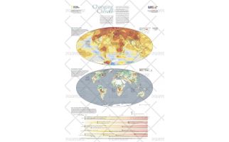 Changing Climate - Published 2007
The scientific evidence is clear: Surface temperatures on Earth are warming at a pace that signals a decisive shift in the global climate, one expected to last for centuries. Climate is changing more rapidly than ever before and human activity is the main cause. Burning of fossil fuels has flooded the atmosphere with heat-trapping carbon dioxide, triggering a 1 degree (F) spike in average global temperature in the past century, largely in the past 30 years. This informative map, published in October 2007 as half of a two-map set with "Greenhouse Earth," reveals evidence which suggests that unless CO2 emissions are slashed, the planet will likely heat up even faster, fundamentally changing the world we live in.
Learn MorePrice from $33.99 -
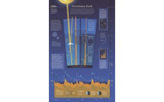 Greenhouse Earth - Published 2007
Published in October 2007 as half of a two-piece set with "Changing Climate," this revealing poster explains how the Earth's atmosphere acts as a greenhouse and how carbon emissions raise the planet's surface temperature. Graphs and charts reveal the origin of emissions, predicted future carbon emission levels, and the warming cycles the planet has experienced in its history.
Learn MorePrice from $33.99 -
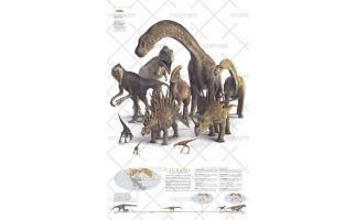
 Planet of the Dinosaurs Gondwana - Published 2007
More than 550 species of dinosaurs have been named, and scientists estimate that more than a thousand others are waiting to be found. When the supercontient Pangaea separated into two great landmasses, Gondwana in the south and Laurasia in the north, dinosaur populations were divided into two main populations that evolved mostly in isolation from each other until they met their end 65 million years ago. This remarkable poster was published in December 2007 as half of a two-piece set. It features ten of the dinosaurs that roamed Gondwana in the southern hemisphere.
Learn MorePrice from $33.99 -
 Planet of the Dinosaurs Laurasia - Published 2007
When the supercontient Pangaea separated into two great landmasses, Gondwana in the south and Laurasia in the north, dinosaur populations were divided into two main populations that evolved mostly in isolation from each other until they met their end 65 million years ago. This remarkable poster was published in December 2007 as half of a two-piece set. It features ten of the dinosaurs that roamed Laurasia in the northern hemisphere. More than 550 species of dinosaurs have been named, and scientists estimate that more than a thousand others are waiting to be found.
Learn MorePrice from $33.99 -
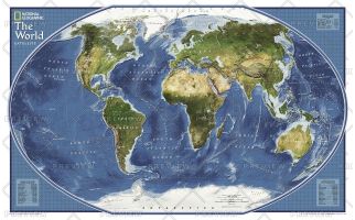 World Explorer Satellite - Published 2011
Satellite map of the world. The topography of the ocean floors is beautifully illustrated.
Learn MorePrice from $27.99 -
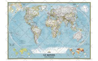 World Map in French
A National Geographic World Map (Carte du Monde en Français) shows crucial geographic details, political boundaries and comes with close up insets and an easy reference index.
Learn MorePrice from $39.99 -
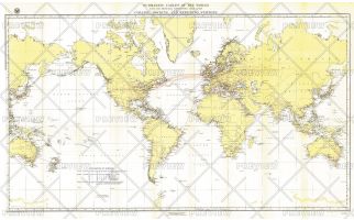 Submarine Cables of the World - Published 1896
Submarine cables have played an important part in the development of world-wide communications since the 1850's. This fascinating map, first develped for the Department of the Navy and published in National Geographic in 1896, shows submarine cables that had been laid, as well as the land-based cable systems that connected to them.
Learn MorePrice from $54.99 -
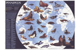 Pinnipeds Around the World - Published 1987
Pinniped means "fin-footed" and refers to seals, sea lions, and walruses. This extraordinary map contains illustrations of the many different species of pinnipeds and interesting facts about where they live, what they eat, and more. Published in April 1987 with the article "Seal and Their Kin," this map also accompanied the map of Antarctica published in the same issue.
Learn MorePrice from $99.99