BACKGROUND
New Brunswick was one of the first provinces to join together to form the Dominion of Canada in 1867, along with Ontario, Quebec and Nova Scotia. Today, the province has experienced immigration on a smaller scale from all over the world and boasts a varied and increasingly multicultural population.
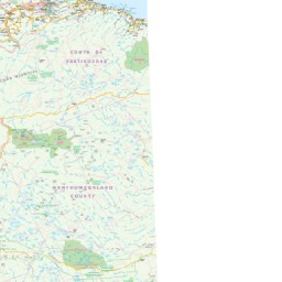
GEOGRAPHY AND AREA
Known as one of Canada’s three Maritime Provinces, it varies from its neighbors both ethnoculturally and physiographically. The province has a significant seacoast and is thus sheltered from the Atlantic Ocean proper and has a large interior which is removed from oceanic effects. New Brunswick, therefore, tends to be defined by its rivers rather than its seacoast.
Bounded by Quebec’s Gaspé Peninsula and Bay of Chaleur and on the east by the Gulf of Saint Lawrence and Northumberland Strait. In the southeast, the Isthmus of Chignecto connects it to Nova Scotia. On its west, the province borders the US state of Maine. Its northern border also includes the Restigouche River and the Baie des Chaleurs. The eastern boundary is entirely coastal – the Gulf of St. Lawrence and Northumberland Strait – and dotted with warm, sandy beaches, featuring the warmest salt water north of Virginia. The province’s southern border is formed by Chignecto Bay and the 24-kilometer wide Isthmus of Chignecto, connecting New Brunswick to Nova Scotia.
The total area including (land and water) is 72, 908 square kilometers.
ECONOMY
The economic scenario as per October 2017, the seasonally-adjusted employment is 73,400 for the goods-producing sector, and 280, 900 for the services-producing sector. Agriculture, fisheries, forestry, and mining are core markets working in the economy. More than 13,000 New Brunswickers work in agriculture, shipping products worth over $1 billion, half of which is from crops, and half of that from potatoes, mostly in the Saint John River valley.
Other products include apples, cranberries, and maple syrup. In 2015, Canada was recognized as the biggest producer of wild blueberries. Fisheries including salmon, crab, and herring and around half of the value of exports which was $1.6 billion came from lobster, which was exported mostly to the United States. Mining too, was historically unimportant, but gradually with time, it began producing lead, zinc, copper, and potash and the industry grew up to $1.1 billion.
DEMOGRAPHICS
New Brunswick is the eighth-most populous province in Canada. As per the Canada 2016 Census, around 747, 101 residents lived in the Canadian province. New Brunswick’s 107 municipalities cover 8.6% of the province’s land mass but are home to 65.3% of its population.
CLIMATE
The entire New Brunswick province experiences a humid continental climate with slightly milder winters on the Gulf of St. Lawrence coastline. The area far north of the province, just above subarctic has very cold winters. Winters are very cold than those being found in Nova Scotia all over the province due to the greater continental influence. Summers are often warm and sometimes hot.
LANDSCAPE & TOURISM
New Brunswick is known for its beautiful sandy beaches in the summer, spectacular autumn foliage, wildflowers in the spring and pure, white snow in the winter. It is also marked by its rolling hills and breathtaking view of valleys, historic and modern architecture that stand in the province’s cities, towns and villages. From majestic rivers including the mighty St. John, the magnificent Restigouche or the Miramichi, the province offers a wide range of attractions to visitors and residents alike. Rolling farmlands, jaw-dropping vistas, vibrant communities, and the world’s highest tides to picturesque forests, river valleys to rocky pinnacles, the beauty and variety New Brunswick offers is unique in the world. The rivers and coastal islands for kayaking, snowy mountains for skiing and quaint Acadian villages for exploring.
ETHNICITY & LANGUAGE
As per 2001 census, the most common ethnicities were French Canadian or Acadian 31%, British Isles 60%, other European 7%, First Nations 3%, Asian Canadian 2%. A significant percent of Irish people were present in coastal areas such as Miramichi and Saint John was 33.6% of Saint John residents lived.
According to the Canadian Constitution, both English and French are the official languages of New Brunswick, making it the only officially bilingual province. You can also buy Canada maps in French here